You are here: Home > Network List > TA - USArray Transportable Network (new EarthScope stations) Stations List
> Station P54A Burton, WV, USA > Earthquake Result Viewer
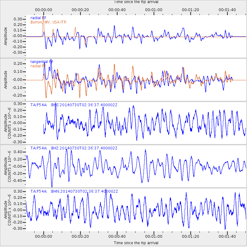
P54A Burton, WV, USA - Earthquake Result Viewer
*The percent match for this event was below the threshold and hence no stack was calculated.
| Earthquake location: |
Southern Mid-Atlantic Ridge |
| Earthquake latitude/longitude: |
-19.1/-12.3 |
| Earthquake time(UTC): |
2014/07/30 (211) 02:24:26 GMT |
| Earthquake Depth: |
9.1 km |
| Earthquake Magnitude: |
5.5 MB |
| Earthquake Catalog/Contributor: |
NEIC PDE/NEIC COMCAT |
|
| Network: |
TA USArray Transportable Network (new EarthScope stations) |
| Station: |
P54A Burton, WV, USA |
| Lat/Lon: |
39.61 N/80.48 W |
| Elevation: |
473 m |
|
| Distance: |
86.3 deg |
| Az: |
314.05 deg |
| Baz: |
118.374 deg |
| Ray Param: |
$rayparam |
*The percent match for this event was below the threshold and hence was not used in the summary stack. |
|
| Radial Match: |
63.414352 % |
| Radial Bump: |
400 |
| Transverse Match: |
60.597473 % |
| Transverse Bump: |
400 |
| SOD ConfigId: |
769524 |
| Insert Time: |
2014-08-13 02:56:18.676 +0000 |
| GWidth: |
2.5 |
| Max Bumps: |
400 |
| Tol: |
0.001 |
|
Signal To Noise
| Channel | StoN | STA | LTA |
| TA:P54A: :BHZ:20140730T02:36:37.400002Z | 1.6930171 | 2.9763046E-7 | 1.7579885E-7 |
| TA:P54A: :BHN:20140730T02:36:37.400002Z | 0.66109157 | 6.779365E-8 | 1.0254805E-7 |
| TA:P54A: :BHE:20140730T02:36:37.400002Z | 1.3906757 | 1.3159911E-7 | 9.462962E-8 |
| Arrivals |
| Ps | |
| PpPs | |
| PsPs/PpSs | |


