You are here: Home > Network List > TA - USArray Transportable Network (new EarthScope stations) Stations List
> Station W54A Cherokee Point, Campobello, SC, USA > Earthquake Result Viewer
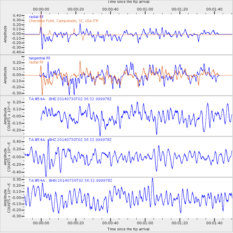
W54A Cherokee Point, Campobello, SC, USA - Earthquake Result Viewer
*The percent match for this event was below the threshold and hence no stack was calculated.
| Earthquake location: |
Southern Mid-Atlantic Ridge |
| Earthquake latitude/longitude: |
-19.1/-12.3 |
| Earthquake time(UTC): |
2014/07/30 (211) 02:24:26 GMT |
| Earthquake Depth: |
9.1 km |
| Earthquake Magnitude: |
5.5 MB |
| Earthquake Catalog/Contributor: |
NEIC PDE/NEIC COMCAT |
|
| Network: |
TA USArray Transportable Network (new EarthScope stations) |
| Station: |
W54A Cherokee Point, Campobello, SC, USA |
| Lat/Lon: |
35.09 N/82.19 W |
| Elevation: |
272 m |
|
| Distance: |
85.4 deg |
| Az: |
309.407 deg |
| Baz: |
117.004 deg |
| Ray Param: |
$rayparam |
*The percent match for this event was below the threshold and hence was not used in the summary stack. |
|
| Radial Match: |
49.920586 % |
| Radial Bump: |
400 |
| Transverse Match: |
63.346043 % |
| Transverse Bump: |
400 |
| SOD ConfigId: |
769524 |
| Insert Time: |
2014-08-13 02:57:52.981 +0000 |
| GWidth: |
2.5 |
| Max Bumps: |
400 |
| Tol: |
0.001 |
|
Signal To Noise
| Channel | StoN | STA | LTA |
| TA:W54A: :BHZ:20140730T02:36:32.999978Z | 2.2534263 | 2.4027455E-7 | 1.0662632E-7 |
| TA:W54A: :BHN:20140730T02:36:32.999978Z | 0.97083205 | 1.1400797E-7 | 1.1743326E-7 |
| TA:W54A: :BHE:20140730T02:36:32.999978Z | 1.6097202 | 1.0544291E-7 | 6.550387E-8 |
| Arrivals |
| Ps | |
| PpPs | |
| PsPs/PpSs | |


