You are here: Home > Network List > II - Global Seismograph Network (GSN - IRIS/IDA) Stations List
> Station TAU Hobart, Tasmania, Australia > Earthquake Result Viewer
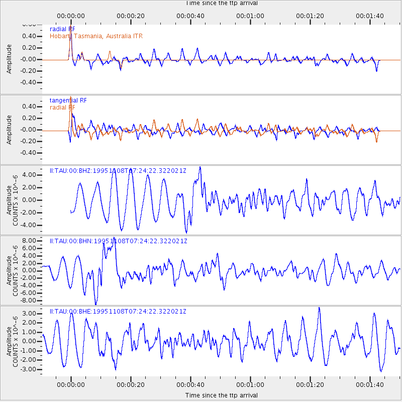
TAU Hobart, Tasmania, Australia - Earthquake Result Viewer
*The percent match for this event was below the threshold and hence no stack was calculated.
| Earthquake location: |
Off W Coast Of Northern Sumatra |
| Earthquake latitude/longitude: |
1.9/95.1 |
| Earthquake time(UTC): |
1995/11/08 (312) 07:14:18 GMT |
| Earthquake Depth: |
33 km |
| Earthquake Magnitude: |
6.1 MB, 6.9 MS, 6.7 UNKNOWN, 6.9 MW |
| Earthquake Catalog/Contributor: |
WHDF/NEIC |
|
| Network: |
II Global Seismograph Network (GSN - IRIS/IDA) |
| Station: |
TAU Hobart, Tasmania, Australia |
| Lat/Lon: |
42.91 S/147.32 E |
| Elevation: |
132 m |
|
| Distance: |
64.7 deg |
| Az: |
140.004 deg |
| Baz: |
299.029 deg |
| Ray Param: |
$rayparam |
*The percent match for this event was below the threshold and hence was not used in the summary stack. |
|
| Radial Match: |
60.45609 % |
| Radial Bump: |
400 |
| Transverse Match: |
56.39706 % |
| Transverse Bump: |
400 |
| SOD ConfigId: |
4480 |
| Insert Time: |
2010-03-02 00:36:25.588 +0000 |
| GWidth: |
2.5 |
| Max Bumps: |
400 |
| Tol: |
0.001 |
|
Signal To Noise
| Channel | StoN | STA | LTA |
| II:TAU:00:BHN:19951108T07:24:22.322021Z | 2.2324586 | 3.6471324E-6 | 1.6336843E-6 |
| II:TAU:00:BHE:19951108T07:24:22.322021Z | 2.4710684 | 2.0283562E-6 | 8.208418E-7 |
| II:TAU:00:BHZ:19951108T07:24:22.322021Z | 0.8265353 | 2.236914E-6 | 2.7063745E-6 |
| Arrivals |
| Ps | |
| PpPs | |
| PsPs/PpSs | |


