You are here: Home > Network List > II - Global Seismograph Network (GSN - IRIS/IDA) Stations List
> Station TAU Hobart, Tasmania, Australia > Earthquake Result Viewer
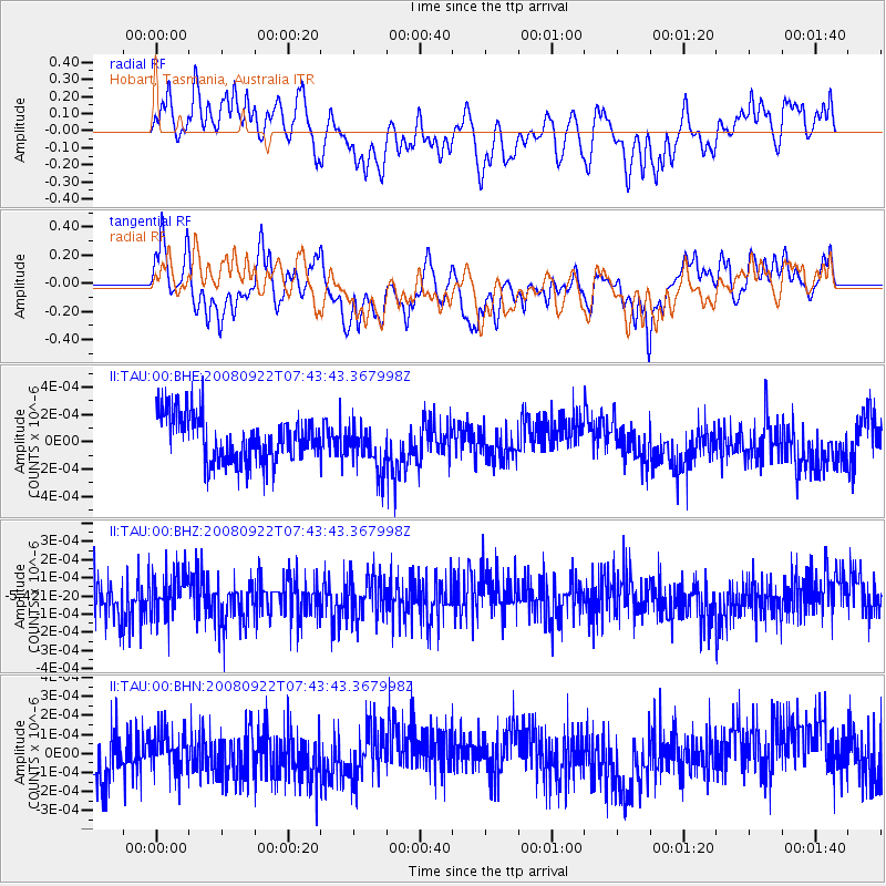
TAU Hobart, Tasmania, Australia - Earthquake Result Viewer
*The percent match for this event was below the threshold and hence no stack was calculated.
| Earthquake location: |
Hokkaido, Japan Region |
| Earthquake latitude/longitude: |
41.6/140.4 |
| Earthquake time(UTC): |
2008/09/22 (266) 07:31:59 GMT |
| Earthquake Depth: |
149 km |
| Earthquake Magnitude: |
5.7 MW, 5.3 MB, 5.6 MW |
| Earthquake Catalog/Contributor: |
WHDF/NEIC |
|
| Network: |
II Global Seismograph Network (GSN - IRIS/IDA) |
| Station: |
TAU Hobart, Tasmania, Australia |
| Lat/Lon: |
42.91 S/147.32 E |
| Elevation: |
132 m |
|
| Distance: |
84.3 deg |
| Az: |
174.933 deg |
| Baz: |
354.825 deg |
| Ray Param: |
$rayparam |
*The percent match for this event was below the threshold and hence was not used in the summary stack. |
|
| Radial Match: |
57.425354 % |
| Radial Bump: |
400 |
| Transverse Match: |
66.49515 % |
| Transverse Bump: |
400 |
| SOD ConfigId: |
2560 |
| Insert Time: |
2010-03-02 00:36:29.540 +0000 |
| GWidth: |
2.5 |
| Max Bumps: |
400 |
| Tol: |
0.001 |
|
Signal To Noise
| Channel | StoN | STA | LTA |
| II:TAU:00:BHZ:20080922T07:43:43.367998Z | 1.1068492 | 1.1504234E-10 | 1.0393678E-10 |
| II:TAU:00:BHN:20080922T07:43:43.367998Z | 0.6120278 | 1.0642821E-10 | 1.738944E-10 |
| II:TAU:00:BHE:20080922T07:43:43.367998Z | 0.9971034 | 1.6934744E-10 | 1.6983939E-10 |
| Arrivals |
| Ps | |
| PpPs | |
| PsPs/PpSs | |


