You are here: Home > Network List > II - Global Seismograph Network (GSN - IRIS/IDA) Stations List
> Station TAU Hobart, Tasmania, Australia > Earthquake Result Viewer
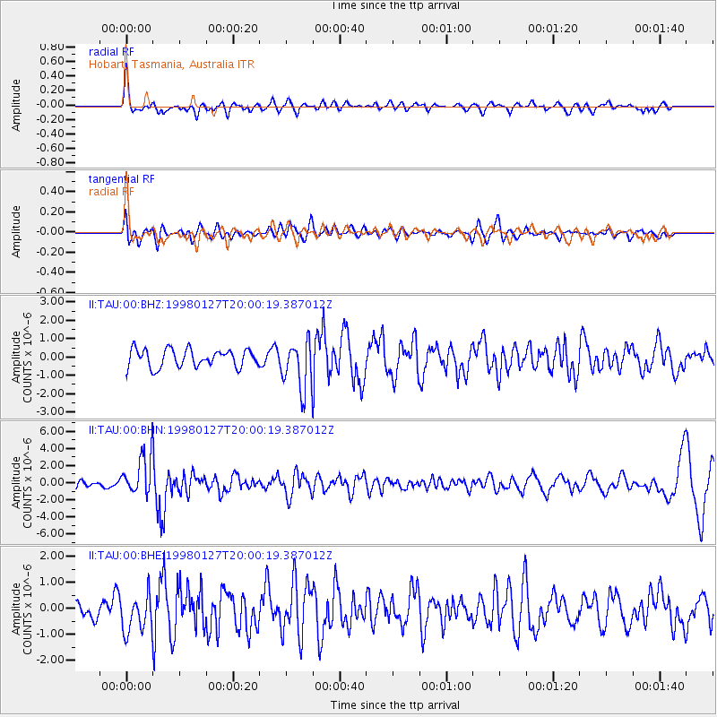
TAU Hobart, Tasmania, Australia - Earthquake Result Viewer
*The percent match for this event was below the threshold and hence no stack was calculated.
| Earthquake location: |
South Of Fiji Islands |
| Earthquake latitude/longitude: |
-22.5/179.0 |
| Earthquake time(UTC): |
1998/01/27 (027) 19:55:01 GMT |
| Earthquake Depth: |
611 km |
| Earthquake Magnitude: |
5.6 MB |
| Earthquake Catalog/Contributor: |
WHDF/NEIC |
|
| Network: |
II Global Seismograph Network (GSN - IRIS/IDA) |
| Station: |
TAU Hobart, Tasmania, Australia |
| Lat/Lon: |
42.91 S/147.32 E |
| Elevation: |
132 m |
|
| Distance: |
33.2 deg |
| Az: |
224.807 deg |
| Baz: |
62.471 deg |
| Ray Param: |
$rayparam |
*The percent match for this event was below the threshold and hence was not used in the summary stack. |
|
| Radial Match: |
76.685135 % |
| Radial Bump: |
400 |
| Transverse Match: |
45.210114 % |
| Transverse Bump: |
400 |
| SOD ConfigId: |
4480 |
| Insert Time: |
2010-03-02 00:36:36.293 +0000 |
| GWidth: |
2.5 |
| Max Bumps: |
400 |
| Tol: |
0.001 |
|
Signal To Noise
| Channel | StoN | STA | LTA |
| II:TAU:00:BHN:19980127T20:00:19.387012Z | 3.349536 | 2.3668747E-6 | 7.066276E-7 |
| II:TAU:00:BHE:19980127T20:00:19.387012Z | 1.3985023 | 7.2536443E-7 | 5.1867227E-7 |
| II:TAU:00:BHZ:19980127T20:00:19.387012Z | 2.7982633 | 1.3496959E-6 | 4.823334E-7 |
| Arrivals |
| Ps | |
| PpPs | |
| PsPs/PpSs | |


