You are here: Home > Network List > AK - Alaska Regional Network Stations List
> Station WRH Wood River Hill > Earthquake Result Viewer
WRH Wood River Hill - Earthquake Result Viewer
| Earthquake location: |
Solomon Islands |
| Earthquake latitude/longitude: |
-7.2/154.8 |
| Earthquake time(UTC): |
2014/07/30 (211) 16:00:58 GMT |
| Earthquake Depth: |
10 km |
| Earthquake Magnitude: |
5.7 MWB |
| Earthquake Catalog/Contributor: |
NEIC PDE/NEIC COMCAT |
|
| Network: |
AK Alaska Regional Network |
| Station: |
WRH Wood River Hill |
| Lat/Lon: |
64.47 N/148.09 W |
| Elevation: |
343 m |
|
| Distance: |
83.0 deg |
| Az: |
21.495 deg |
| Baz: |
237.041 deg |
| Ray Param: |
0.04649201 |
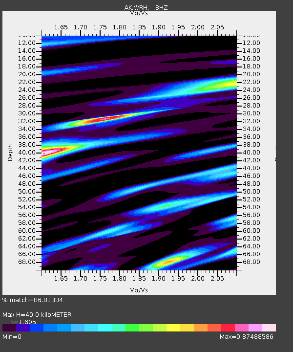
| Estimated Moho Depth: |
40.0 km |
| Estimated Crust Vp/Vs: |
1.61 |
| Assumed Crust Vp: |
6.566 km/s |
| Estimated Crust Vs: |
4.091 km/s |
| Estimated Crust Poisson's Ratio: |
0.18 |
|
| Radial Match: |
86.81334 % |
| Radial Bump: |
400 |
| Transverse Match: |
69.272194 % |
| Transverse Bump: |
400 |
| SOD ConfigId: |
769524 |
| Insert Time: |
2014-08-13 16:09:40.490 +0000 |
| GWidth: |
2.5 |
| Max Bumps: |
400 |
| Tol: |
0.001 |
|

Signal To Noise
| Channel | StoN | STA | LTA |
| AK:WRH: :BHZ:20140730T16:12:52.587971Z | 9.806261 | 4.856679E-7 | 4.952631E-8 |
| AK:WRH: :BHN:20140730T16:12:52.587971Z | 1.448981 | 9.5756796E-8 | 6.608561E-8 |
| AK:WRH: :BHE:20140730T16:12:52.587971Z | 1.1688496 | 8.919609E-8 | 7.631101E-8 |
| Arrivals |
| Ps | 3.8 SECOND |
| PpPs | 15 SECOND |
| PsPs/PpSs | 19 SECOND |


