You are here: Home > Network List > AV - Alaska Volcano Observatory Stations List
> Station MAPS Pakushin Southeast, Makushin Volcano, Alaska > Earthquake Result Viewer
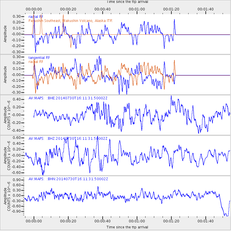
MAPS Pakushin Southeast, Makushin Volcano, Alaska - Earthquake Result Viewer
*The percent match for this event was below the threshold and hence no stack was calculated.
| Earthquake location: |
Solomon Islands |
| Earthquake latitude/longitude: |
-7.2/154.8 |
| Earthquake time(UTC): |
2014/07/30 (211) 16:00:58 GMT |
| Earthquake Depth: |
10 km |
| Earthquake Magnitude: |
5.7 MWB |
| Earthquake Catalog/Contributor: |
NEIC PDE/NEIC COMCAT |
|
| Network: |
AV Alaska Volcano Observatory |
| Station: |
MAPS Pakushin Southeast, Makushin Volcano, Alaska |
| Lat/Lon: |
53.81 N/166.94 W |
| Elevation: |
333 m |
|
| Distance: |
68.8 deg |
| Az: |
23.182 deg |
| Baz: |
221.193 deg |
| Ray Param: |
$rayparam |
*The percent match for this event was below the threshold and hence was not used in the summary stack. |
|
| Radial Match: |
64.03217 % |
| Radial Bump: |
400 |
| Transverse Match: |
65.77369 % |
| Transverse Bump: |
361 |
| SOD ConfigId: |
769524 |
| Insert Time: |
2014-08-13 16:11:40.716 +0000 |
| GWidth: |
2.5 |
| Max Bumps: |
400 |
| Tol: |
0.001 |
|
Signal To Noise
| Channel | StoN | STA | LTA |
| AV:MAPS: :BHZ:20140730T16:11:31.50002Z | 2.5895271 | 2.765759E-7 | 1.0680556E-7 |
| AV:MAPS: :BHN:20140730T16:11:31.50002Z | 1.6338822 | 1.7036221E-7 | 1.0426835E-7 |
| AV:MAPS: :BHE:20140730T16:11:31.50002Z | 2.2965817 | 1.9354857E-7 | 8.4276806E-8 |
| Arrivals |
| Ps | |
| PpPs | |
| PsPs/PpSs | |


