You are here: Home > Network List > TA - USArray Transportable Network (new EarthScope stations) Stations List
> Station A21K Barrow, AK, USA > Earthquake Result Viewer
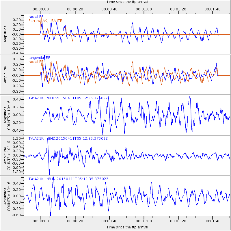
A21K Barrow, AK, USA - Earthquake Result Viewer
*The percent match for this event was below the threshold and hence no stack was calculated.
| Earthquake location: |
Northern Molucca Sea |
| Earthquake latitude/longitude: |
2.1/126.7 |
| Earthquake time(UTC): |
2015/04/11 (101) 05:00:42 GMT |
| Earthquake Depth: |
50 km |
| Earthquake Magnitude: |
5.6 MWC, 5.5 MWB, 5.6 MWC |
| Earthquake Catalog/Contributor: |
NEIC PDE/NEIC COMCAT |
|
| Network: |
TA USArray Transportable Network (new EarthScope stations) |
| Station: |
A21K Barrow, AK, USA |
| Lat/Lon: |
71.32 N/156.62 W |
| Elevation: |
577 m |
|
| Distance: |
83.8 deg |
| Az: |
18.385 deg |
| Baz: |
258.039 deg |
| Ray Param: |
$rayparam |
*The percent match for this event was below the threshold and hence was not used in the summary stack. |
|
| Radial Match: |
64.32628 % |
| Radial Bump: |
400 |
| Transverse Match: |
66.42478 % |
| Transverse Bump: |
400 |
| SOD ConfigId: |
7422571 |
| Insert Time: |
2019-04-18 03:57:02.282 +0000 |
| GWidth: |
2.5 |
| Max Bumps: |
400 |
| Tol: |
0.001 |
|
Signal To Noise
| Channel | StoN | STA | LTA |
| TA:A21K: :BHZ:20150411T05:12:35.37502Z | 6.9617634 | 4.6140386E-7 | 6.627687E-8 |
| TA:A21K: :BHN:20150411T05:12:35.37502Z | 1.359189 | 1.4087783E-7 | 1.0364844E-7 |
| TA:A21K: :BHE:20150411T05:12:35.37502Z | 1.8468139 | 2.2189593E-7 | 1.2015067E-7 |
| Arrivals |
| Ps | |
| PpPs | |
| PsPs/PpSs | |


