You are here: Home > Network List > TA - USArray Transportable Network (new EarthScope stations) Stations List
> Station I23K Minto, Yukon-Koyukuk, AK, USA > Earthquake Result Viewer
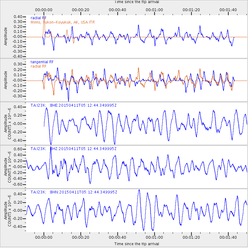
I23K Minto, Yukon-Koyukuk, AK, USA - Earthquake Result Viewer
*The percent match for this event was below the threshold and hence no stack was calculated.
| Earthquake location: |
Northern Molucca Sea |
| Earthquake latitude/longitude: |
2.1/126.7 |
| Earthquake time(UTC): |
2015/04/11 (101) 05:00:42 GMT |
| Earthquake Depth: |
50 km |
| Earthquake Magnitude: |
5.6 MWC, 5.5 MWB, 5.6 MWC |
| Earthquake Catalog/Contributor: |
NEIC PDE/NEIC COMCAT |
|
| Network: |
TA USArray Transportable Network (new EarthScope stations) |
| Station: |
I23K Minto, Yukon-Koyukuk, AK, USA |
| Lat/Lon: |
65.15 N/149.36 W |
| Elevation: |
149 m |
|
| Distance: |
85.5 deg |
| Az: |
24.931 deg |
| Baz: |
265.396 deg |
| Ray Param: |
$rayparam |
*The percent match for this event was below the threshold and hence was not used in the summary stack. |
|
| Radial Match: |
45.98845 % |
| Radial Bump: |
354 |
| Transverse Match: |
60.88082 % |
| Transverse Bump: |
400 |
| SOD ConfigId: |
7422571 |
| Insert Time: |
2019-04-18 03:57:02.837 +0000 |
| GWidth: |
2.5 |
| Max Bumps: |
400 |
| Tol: |
0.001 |
|
Signal To Noise
| Channel | StoN | STA | LTA |
| TA:I23K: :BHZ:20150411T05:12:44.349995Z | 2.5880852 | 2.6738343E-7 | 1.03313226E-7 |
| TA:I23K: :BHN:20150411T05:12:44.349995Z | 1.8999949 | 2.1312799E-7 | 1.1217293E-7 |
| TA:I23K: :BHE:20150411T05:12:44.349995Z | 1.3469999 | 2.405517E-7 | 1.7858333E-7 |
| Arrivals |
| Ps | |
| PpPs | |
| PsPs/PpSs | |


