You are here: Home > Network List > II - Global Seismograph Network (GSN - IRIS/IDA) Stations List
> Station TAU Hobart, Tasmania, Australia > Earthquake Result Viewer
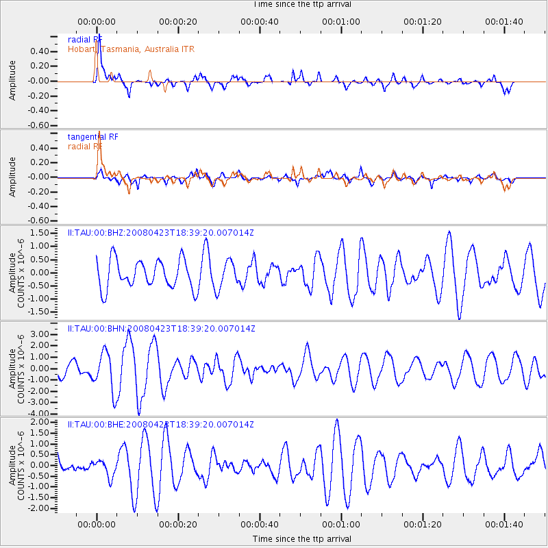
TAU Hobart, Tasmania, Australia - Earthquake Result Viewer
*The percent match for this event was below the threshold and hence no stack was calculated.
| Earthquake location: |
Taiwan Region |
| Earthquake latitude/longitude: |
22.9/121.6 |
| Earthquake time(UTC): |
2008/04/23 (114) 18:28:41 GMT |
| Earthquake Depth: |
10 km |
| Earthquake Magnitude: |
5.6 MB, 5.9 MS, 6.0 MW, 6.0 MW |
| Earthquake Catalog/Contributor: |
WHDF/NEIC |
|
| Network: |
II Global Seismograph Network (GSN - IRIS/IDA) |
| Station: |
TAU Hobart, Tasmania, Australia |
| Lat/Lon: |
42.91 S/147.32 E |
| Elevation: |
132 m |
|
| Distance: |
69.6 deg |
| Az: |
160.129 deg |
| Baz: |
334.743 deg |
| Ray Param: |
$rayparam |
*The percent match for this event was below the threshold and hence was not used in the summary stack. |
|
| Radial Match: |
68.58795 % |
| Radial Bump: |
400 |
| Transverse Match: |
54.357803 % |
| Transverse Bump: |
400 |
| SOD ConfigId: |
2504 |
| Insert Time: |
2010-03-02 00:36:52.072 +0000 |
| GWidth: |
2.5 |
| Max Bumps: |
400 |
| Tol: |
0.001 |
|
Signal To Noise
| Channel | StoN | STA | LTA |
| II:TAU:00:BHN:20080423T18:39:20.007014Z | 3.2124834 | 1.7699483E-6 | 5.509595E-7 |
| II:TAU:00:BHE:20080423T18:39:20.007014Z | 0.5359181 | 3.9141185E-7 | 7.3035756E-7 |
| II:TAU:00:BHZ:20080423T18:39:20.007014Z | 0.9704714 | 5.2186704E-7 | 5.3774596E-7 |
| Arrivals |
| Ps | |
| PpPs | |
| PsPs/PpSs | |


