You are here: Home > Network List > II - Global Seismograph Network (GSN - IRIS/IDA) Stations List
> Station TAU Hobart, Tasmania, Australia > Earthquake Result Viewer
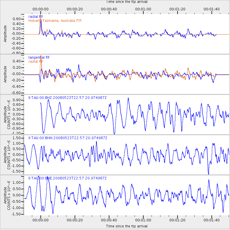
TAU Hobart, Tasmania, Australia - Earthquake Result Viewer
*The percent match for this event was below the threshold and hence no stack was calculated.
| Earthquake location: |
Banda Sea |
| Earthquake latitude/longitude: |
-7.1/129.5 |
| Earthquake time(UTC): |
2008/05/23 (144) 22:50:37 GMT |
| Earthquake Depth: |
125 km |
| Earthquake Magnitude: |
5.8 MB, 5.7 MW, 5.7 MW |
| Earthquake Catalog/Contributor: |
WHDF/NEIC |
|
| Network: |
II Global Seismograph Network (GSN - IRIS/IDA) |
| Station: |
TAU Hobart, Tasmania, Australia |
| Lat/Lon: |
42.91 S/147.32 E |
| Elevation: |
132 m |
|
| Distance: |
39.0 deg |
| Az: |
159.053 deg |
| Baz: |
331.122 deg |
| Ray Param: |
$rayparam |
*The percent match for this event was below the threshold and hence was not used in the summary stack. |
|
| Radial Match: |
62.233685 % |
| Radial Bump: |
347 |
| Transverse Match: |
54.309555 % |
| Transverse Bump: |
400 |
| SOD ConfigId: |
2504 |
| Insert Time: |
2010-03-02 00:36:53.840 +0000 |
| GWidth: |
2.5 |
| Max Bumps: |
400 |
| Tol: |
0.001 |
|
Signal To Noise
| Channel | StoN | STA | LTA |
| II:TAU:00:BHN:20080523T22:57:20.974987Z | 1.1595879 | 5.145437E-7 | 4.437298E-7 |
| II:TAU:00:BHE:20080523T22:57:20.974987Z | 2.6097996 | 1.0201165E-6 | 3.9087928E-7 |
| II:TAU:00:BHZ:20080523T22:57:20.974987Z | 0.4034377 | 1.866283E-7 | 4.6259507E-7 |
| Arrivals |
| Ps | |
| PpPs | |
| PsPs/PpSs | |


