You are here: Home > Network List > II - Global Seismograph Network (GSN - IRIS/IDA) Stations List
> Station TAU Hobart, Tasmania, Australia > Earthquake Result Viewer
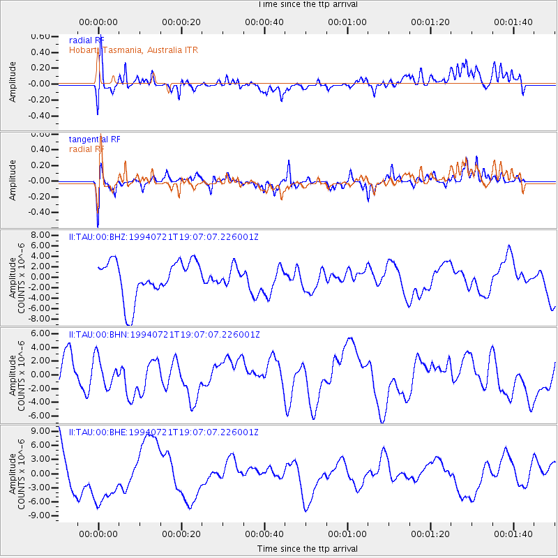
TAU Hobart, Tasmania, Australia - Earthquake Result Viewer
*The percent match for this event was below the threshold and hence no stack was calculated.
| Earthquake location: |
Sea Of Japan |
| Earthquake latitude/longitude: |
41.2/132.4 |
| Earthquake time(UTC): |
1994/07/21 (202) 18:55:58 GMT |
| Earthquake Depth: |
515 km |
| Earthquake Magnitude: |
5.7 MB |
| Earthquake Catalog/Contributor: |
WHDF/NEIC |
|
| Network: |
II Global Seismograph Network (GSN - IRIS/IDA) |
| Station: |
TAU Hobart, Tasmania, Australia |
| Lat/Lon: |
42.91 S/147.32 E |
| Elevation: |
132 m |
|
| Distance: |
84.8 deg |
| Az: |
169.016 deg |
| Baz: |
348.712 deg |
| Ray Param: |
$rayparam |
*The percent match for this event was below the threshold and hence was not used in the summary stack. |
|
| Radial Match: |
49.05413 % |
| Radial Bump: |
400 |
| Transverse Match: |
54.323975 % |
| Transverse Bump: |
400 |
| SOD ConfigId: |
4480 |
| Insert Time: |
2010-03-02 00:37:02.635 +0000 |
| GWidth: |
2.5 |
| Max Bumps: |
400 |
| Tol: |
0.001 |
|
Signal To Noise
| Channel | StoN | STA | LTA |
| II:TAU:00:BHN:19940721T19:07:07.226001Z | 0.60201913 | 2.0483476E-6 | 3.4024629E-6 |
| II:TAU:00:BHE:19940721T19:07:07.226001Z | 1.4463805 | 5.592406E-6 | 3.8664834E-6 |
| II:TAU:00:BHZ:19940721T19:07:07.226001Z | 0.47726613 | 1.7034163E-6 | 3.5691119E-6 |
| Arrivals |
| Ps | |
| PpPs | |
| PsPs/PpSs | |


