You are here: Home > Network List > II - Global Seismograph Network (GSN - IRIS/IDA) Stations List
> Station TAU Hobart, Tasmania, Australia > Earthquake Result Viewer
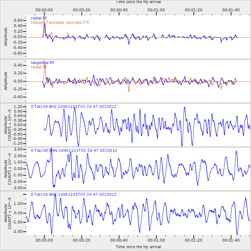
TAU Hobart, Tasmania, Australia - Earthquake Result Viewer
*The percent match for this event was below the threshold and hence no stack was calculated.
| Earthquake location: |
New Ireland Region, P.N.G. |
| Earthquake latitude/longitude: |
-1.3/149.5 |
| Earthquake time(UTC): |
1996/11/01 (306) 03:32:34 GMT |
| Earthquake Depth: |
33 km |
| Earthquake Magnitude: |
5.7 MB, 5.7 MS, 5.9 UNKNOWN, 5.8 MW |
| Earthquake Catalog/Contributor: |
WHDF/NEIC |
|
| Network: |
II Global Seismograph Network (GSN - IRIS/IDA) |
| Station: |
TAU Hobart, Tasmania, Australia |
| Lat/Lon: |
42.91 S/147.32 E |
| Elevation: |
132 m |
|
| Distance: |
41.5 deg |
| Az: |
182.446 deg |
| Baz: |
3.329 deg |
| Ray Param: |
$rayparam |
*The percent match for this event was below the threshold and hence was not used in the summary stack. |
|
| Radial Match: |
66.557915 % |
| Radial Bump: |
324 |
| Transverse Match: |
61.94491 % |
| Transverse Bump: |
400 |
| SOD ConfigId: |
4480 |
| Insert Time: |
2010-03-02 00:37:07.387 +0000 |
| GWidth: |
2.5 |
| Max Bumps: |
400 |
| Tol: |
0.001 |
|
Signal To Noise
| Channel | StoN | STA | LTA |
| II:TAU:00:BHN:19961101T03:39:47.932001Z | 2.9543033 | 1.5425801E-6 | 5.221468E-7 |
| II:TAU:00:BHE:19961101T03:39:47.932001Z | 1.691874 | 9.4288197E-7 | 5.573003E-7 |
| II:TAU:00:BHZ:19961101T03:39:47.932001Z | 0.57240146 | 3.1443275E-7 | 5.4932207E-7 |
| Arrivals |
| Ps | |
| PpPs | |
| PsPs/PpSs | |


