You are here: Home > Network List > II - Global Seismograph Network (GSN - IRIS/IDA) Stations List
> Station TAU Hobart, Tasmania, Australia > Earthquake Result Viewer
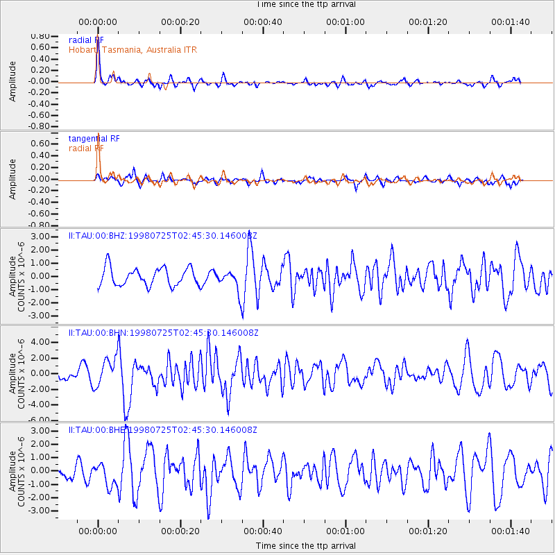
TAU Hobart, Tasmania, Australia - Earthquake Result Viewer
*The percent match for this event was below the threshold and hence no stack was calculated.
| Earthquake location: |
Vanuatu Islands |
| Earthquake latitude/longitude: |
-13.6/166.9 |
| Earthquake time(UTC): |
1998/07/25 (206) 02:39:23 GMT |
| Earthquake Depth: |
44 km |
| Earthquake Magnitude: |
5.9 MB, 6.0 MS, 6.3 UNKNOWN, 6.2 MW |
| Earthquake Catalog/Contributor: |
WHDF/NEIC |
|
| Network: |
II Global Seismograph Network (GSN - IRIS/IDA) |
| Station: |
TAU Hobart, Tasmania, Australia |
| Lat/Lon: |
42.91 S/147.32 E |
| Elevation: |
132 m |
|
| Distance: |
33.7 deg |
| Az: |
206.283 deg |
| Baz: |
35.874 deg |
| Ray Param: |
$rayparam |
*The percent match for this event was below the threshold and hence was not used in the summary stack. |
|
| Radial Match: |
77.61158 % |
| Radial Bump: |
344 |
| Transverse Match: |
67.30305 % |
| Transverse Bump: |
400 |
| SOD ConfigId: |
4480 |
| Insert Time: |
2010-03-02 00:37:08.680 +0000 |
| GWidth: |
2.5 |
| Max Bumps: |
400 |
| Tol: |
0.001 |
|
Signal To Noise
| Channel | StoN | STA | LTA |
| II:TAU:00:BHN:19980725T02:45:30.146008Z | 2.3452113 | 1.8710405E-6 | 7.978132E-7 |
| II:TAU:00:BHE:19980725T02:45:30.146008Z | 1.4040263 | 8.6334785E-7 | 6.149086E-7 |
| II:TAU:00:BHZ:19980725T02:45:30.146008Z | 1.267863 | 8.527889E-7 | 6.7261914E-7 |
| Arrivals |
| Ps | |
| PpPs | |
| PsPs/PpSs | |


