You are here: Home > Network List > II - Global Seismograph Network (GSN - IRIS/IDA) Stations List
> Station TAU Hobart, Tasmania, Australia > Earthquake Result Viewer
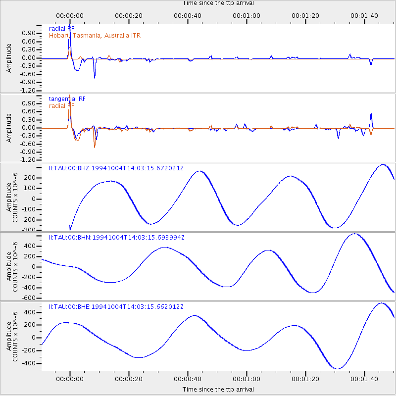
TAU Hobart, Tasmania, Australia - Earthquake Result Viewer
*The percent match for this event was below the threshold and hence no stack was calculated.
| Earthquake location: |
Kuril Islands |
| Earthquake latitude/longitude: |
43.8/147.5 |
| Earthquake time(UTC): |
1994/10/04 (277) 13:51:08 GMT |
| Earthquake Depth: |
33 km |
| Earthquake Magnitude: |
5.6 MB |
| Earthquake Catalog/Contributor: |
WHDF/NEIC |
|
| Network: |
II Global Seismograph Network (GSN - IRIS/IDA) |
| Station: |
TAU Hobart, Tasmania, Australia |
| Lat/Lon: |
42.91 S/147.32 E |
| Elevation: |
132 m |
|
| Distance: |
86.4 deg |
| Az: |
180.132 deg |
| Baz: |
0.13 deg |
| Ray Param: |
$rayparam |
*The percent match for this event was below the threshold and hence was not used in the summary stack. |
|
| Radial Match: |
93.69277 % |
| Radial Bump: |
392 |
| Transverse Match: |
79.421005 % |
| Transverse Bump: |
400 |
| SOD ConfigId: |
4480 |
| Insert Time: |
2010-03-02 00:37:12.499 +0000 |
| GWidth: |
2.5 |
| Max Bumps: |
400 |
| Tol: |
0.001 |
|
Signal To Noise
| Channel | StoN | STA | LTA |
| II:TAU:00:BHN:19941004T14:03:15.693994Z | 0.589233 | 4.8786354E-5 | 8.2796374E-5 |
| II:TAU:00:BHE:19941004T14:03:15.662012Z | 3.1160724 | 2.8227776E-4 | 9.058767E-5 |
| II:TAU:00:BHZ:19941004T14:03:15.672021Z | 1.5430566 | 2.0075438E-4 | 1.3010176E-4 |
| Arrivals |
| Ps | |
| PpPs | |
| PsPs/PpSs | |


