You are here: Home > Network List > II - Global Seismograph Network (GSN - IRIS/IDA) Stations List
> Station TAU Hobart, Tasmania, Australia > Earthquake Result Viewer
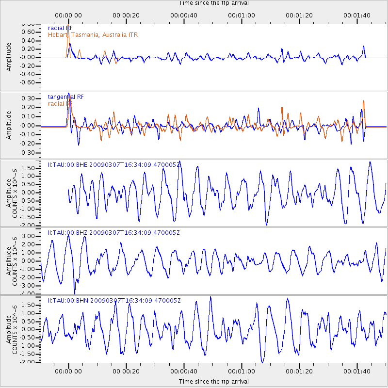
TAU Hobart, Tasmania, Australia - Earthquake Result Viewer
*The percent match for this event was below the threshold and hence no stack was calculated.
| Earthquake location: |
Flores Region, Indonesia |
| Earthquake latitude/longitude: |
-8.4/123.6 |
| Earthquake time(UTC): |
2009/03/07 (066) 16:27:20 GMT |
| Earthquake Depth: |
172 km |
| Earthquake Magnitude: |
5.6 MB |
| Earthquake Catalog/Contributor: |
WHDF/NEIC |
|
| Network: |
II Global Seismograph Network (GSN - IRIS/IDA) |
| Station: |
TAU Hobart, Tasmania, Australia |
| Lat/Lon: |
42.91 S/147.32 E |
| Elevation: |
132 m |
|
| Distance: |
40.2 deg |
| Az: |
152.758 deg |
| Baz: |
321.938 deg |
| Ray Param: |
$rayparam |
*The percent match for this event was below the threshold and hence was not used in the summary stack. |
|
| Radial Match: |
60.07344 % |
| Radial Bump: |
400 |
| Transverse Match: |
59.844017 % |
| Transverse Bump: |
400 |
| SOD ConfigId: |
2658 |
| Insert Time: |
2010-03-02 00:37:18.451 +0000 |
| GWidth: |
2.5 |
| Max Bumps: |
400 |
| Tol: |
0.001 |
|
Signal To Noise
| Channel | StoN | STA | LTA |
| II:TAU:00:BHZ:20090307T16:34:09.470005Z | 2.5155823 | 2.2279644E-6 | 8.856655E-7 |
| II:TAU:00:BHN:20090307T16:34:09.470005Z | 0.3667557 | 4.1025066E-7 | 1.1185938E-6 |
| II:TAU:00:BHE:20090307T16:34:09.470005Z | 1.3347565 | 9.0453347E-7 | 6.776768E-7 |
| Arrivals |
| Ps | |
| PpPs | |
| PsPs/PpSs | |


