You are here: Home > Network List > TA - USArray Transportable Network (new EarthScope stations) Stations List
> Station I23K Minto, Yukon-Koyukuk, AK, USA > Earthquake Result Viewer
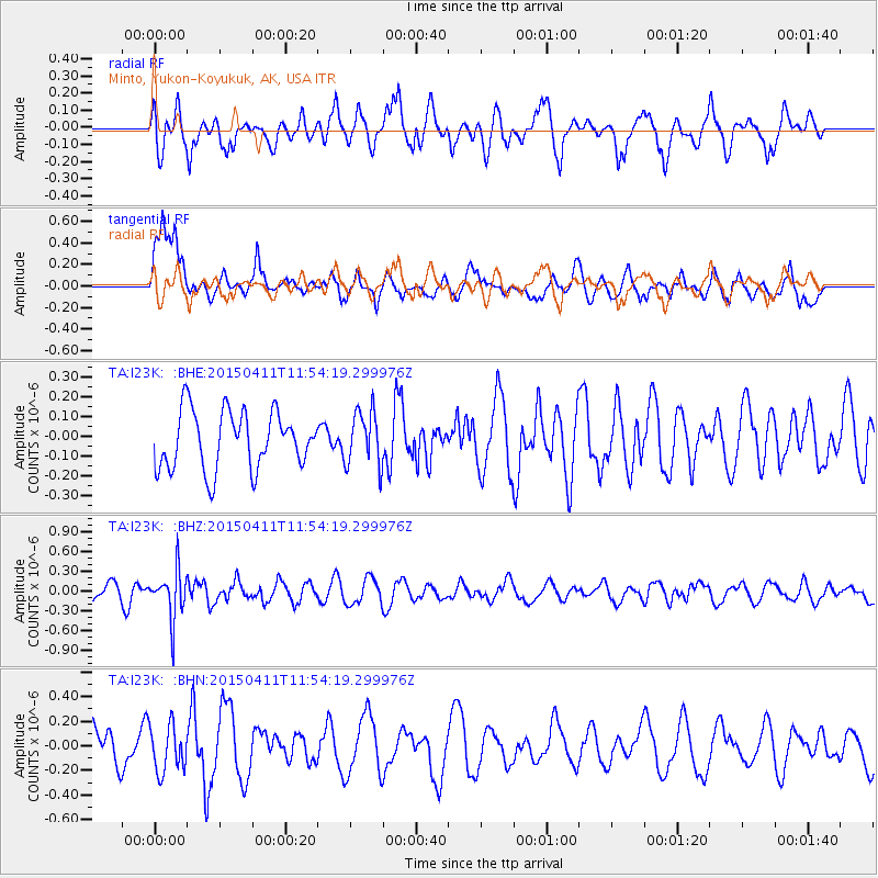
I23K Minto, Yukon-Koyukuk, AK, USA - Earthquake Result Viewer
*The percent match for this event was below the threshold and hence no stack was calculated.
| Earthquake location: |
Celebes Sea |
| Earthquake latitude/longitude: |
4.8/124.9 |
| Earthquake time(UTC): |
2015/04/11 (101) 11:42:53 GMT |
| Earthquake Depth: |
297 km |
| Earthquake Magnitude: |
5.2 MW, 4.9 mb |
| Earthquake Catalog/Contributor: |
ISC/ISC |
|
| Network: |
TA USArray Transportable Network (new EarthScope stations) |
| Station: |
I23K Minto, Yukon-Koyukuk, AK, USA |
| Lat/Lon: |
65.15 N/149.36 W |
| Elevation: |
149 m |
|
| Distance: |
83.9 deg |
| Az: |
25.076 deg |
| Baz: |
268.126 deg |
| Ray Param: |
$rayparam |
*The percent match for this event was below the threshold and hence was not used in the summary stack. |
|
| Radial Match: |
70.35425 % |
| Radial Bump: |
400 |
| Transverse Match: |
60.923637 % |
| Transverse Bump: |
400 |
| SOD ConfigId: |
7422571 |
| Insert Time: |
2019-04-18 04:02:56.585 +0000 |
| GWidth: |
2.5 |
| Max Bumps: |
400 |
| Tol: |
0.001 |
|
Signal To Noise
| Channel | StoN | STA | LTA |
| TA:I23K: :BHZ:20150411T11:54:19.299976Z | 2.9734216 | 3.5908425E-7 | 1.2076467E-7 |
| TA:I23K: :BHN:20150411T11:54:19.299976Z | 0.8337508 | 1.8795747E-7 | 2.2543604E-7 |
| TA:I23K: :BHE:20150411T11:54:19.299976Z | 0.951423 | 1.3882807E-7 | 1.4591625E-7 |
| Arrivals |
| Ps | |
| PpPs | |
| PsPs/PpSs | |


