You are here: Home > Network List > TJ - Tajikistan National Seismic Network Stations List
> Station SHAA Shaartuz, Tajikistan > Earthquake Result Viewer
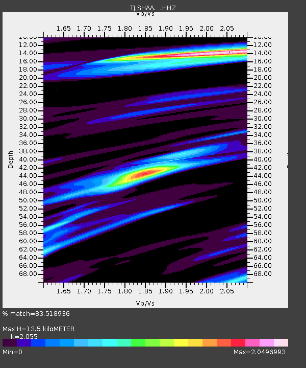
SHAA Shaartuz, Tajikistan - Earthquake Result Viewer
| Earthquake location: |
Andaman Islands, India Region |
| Earthquake latitude/longitude: |
12.4/95.2 |
| Earthquake time(UTC): |
2014/07/31 (212) 13:41:01 GMT |
| Earthquake Depth: |
10 km |
| Earthquake Magnitude: |
5.8 MB |
| Earthquake Catalog/Contributor: |
NEIC PDE/NEIC COMCAT |
|
| Network: |
TJ Tajikistan National Seismic Network |
| Station: |
SHAA Shaartuz, Tajikistan |
| Lat/Lon: |
37.56 N/68.12 E |
| Elevation: |
868 m |
|
| Distance: |
34.8 deg |
| Az: |
320.646 deg |
| Baz: |
128.786 deg |
| Ray Param: |
0.0775355 |
| Estimated Moho Depth: |
13.5 km |
| Estimated Crust Vp/Vs: |
2.06 |
| Assumed Crust Vp: |
6.213 km/s |
| Estimated Crust Vs: |
3.024 km/s |
| Estimated Crust Poisson's Ratio: |
0.34 |
|
| Radial Match: |
83.518936 % |
| Radial Bump: |
400 |
| Transverse Match: |
56.053055 % |
| Transverse Bump: |
400 |
| SOD ConfigId: |
769524 |
| Insert Time: |
2014-08-14 14:16:58.649 +0000 |
| GWidth: |
2.5 |
| Max Bumps: |
400 |
| Tol: |
0.001 |
|

Signal To Noise
| Channel | StoN | STA | LTA |
| TJ:SHAA: :HHZ:20140731T13:47:21.379999Z | 9.728805 | 1.8876877E-6 | 1.940308E-7 |
| TJ:SHAA: :HHN:20140731T13:47:21.379999Z | 2.3635223 | 3.2268582E-7 | 1.3652752E-7 |
| TJ:SHAA: :HHE:20140731T13:47:21.379999Z | 3.906964 | 7.9835456E-7 | 2.0434142E-7 |
| Arrivals |
| Ps | 2.4 SECOND |
| PpPs | 6.2 SECOND |
| PsPs/PpSs | 8.7 SECOND |


