You are here: Home > Network List > II - Global Seismograph Network (GSN - IRIS/IDA) Stations List
> Station TAU Hobart, Tasmania, Australia > Earthquake Result Viewer
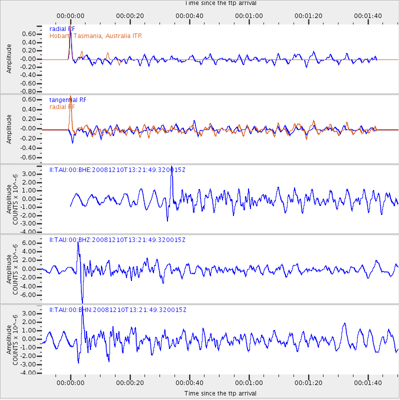
TAU Hobart, Tasmania, Australia - Earthquake Result Viewer
*The percent match for this event was below the threshold and hence no stack was calculated.
| Earthquake location: |
Santa Cruz Islands |
| Earthquake latitude/longitude: |
-12.3/166.6 |
| Earthquake time(UTC): |
2008/12/10 (345) 13:15:34 GMT |
| Earthquake Depth: |
51 km |
| Earthquake Magnitude: |
5.7 MB, 6.0 MW, 6.0 MW |
| Earthquake Catalog/Contributor: |
WHDF/NEIC |
|
| Network: |
II Global Seismograph Network (GSN - IRIS/IDA) |
| Station: |
TAU Hobart, Tasmania, Australia |
| Lat/Lon: |
42.91 S/147.32 E |
| Elevation: |
132 m |
|
| Distance: |
34.7 deg |
| Az: |
205.162 deg |
| Baz: |
34.439 deg |
| Ray Param: |
$rayparam |
*The percent match for this event was below the threshold and hence was not used in the summary stack. |
|
| Radial Match: |
71.978745 % |
| Radial Bump: |
333 |
| Transverse Match: |
70.03688 % |
| Transverse Bump: |
385 |
| SOD ConfigId: |
2658 |
| Insert Time: |
2010-03-02 00:37:38.008 +0000 |
| GWidth: |
2.5 |
| Max Bumps: |
400 |
| Tol: |
0.001 |
|
Signal To Noise
| Channel | StoN | STA | LTA |
| II:TAU:00:BHZ:20081210T13:21:49.320015Z | 7.0966673 | 3.0564513E-6 | 4.3068826E-7 |
| II:TAU:00:BHN:20081210T13:21:49.320015Z | 3.2825334 | 1.4351842E-6 | 4.372185E-7 |
| II:TAU:00:BHE:20081210T13:21:49.320015Z | 2.8796058 | 1.4597673E-6 | 5.06933E-7 |
| Arrivals |
| Ps | |
| PpPs | |
| PsPs/PpSs | |


