You are here: Home > Network List > II - Global Seismograph Network (GSN - IRIS/IDA) Stations List
> Station TAU Hobart, Tasmania, Australia > Earthquake Result Viewer
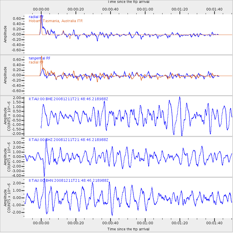
TAU Hobart, Tasmania, Australia - Earthquake Result Viewer
*The percent match for this event was below the threshold and hence no stack was calculated.
| Earthquake location: |
Minahassa Peninsula, Sulawesi |
| Earthquake latitude/longitude: |
0.1/123.4 |
| Earthquake time(UTC): |
2008/12/11 (346) 21:40:52 GMT |
| Earthquake Depth: |
133 km |
| Earthquake Magnitude: |
6.1 MB, 5.9 MW, 5.9 MW |
| Earthquake Catalog/Contributor: |
WHDF/NEIC |
|
| Network: |
II Global Seismograph Network (GSN - IRIS/IDA) |
| Station: |
TAU Hobart, Tasmania, Australia |
| Lat/Lon: |
42.91 S/147.32 E |
| Elevation: |
132 m |
|
| Distance: |
47.9 deg |
| Az: |
156.337 deg |
| Baz: |
326.887 deg |
| Ray Param: |
$rayparam |
*The percent match for this event was below the threshold and hence was not used in the summary stack. |
|
| Radial Match: |
65.485916 % |
| Radial Bump: |
384 |
| Transverse Match: |
54.598316 % |
| Transverse Bump: |
400 |
| SOD ConfigId: |
2658 |
| Insert Time: |
2010-03-02 00:37:39.923 +0000 |
| GWidth: |
2.5 |
| Max Bumps: |
400 |
| Tol: |
0.001 |
|
Signal To Noise
| Channel | StoN | STA | LTA |
| II:TAU:00:BHZ:20081211T21:48:46.218988Z | 4.254444 | 1.8614788E-6 | 4.375375E-7 |
| II:TAU:00:BHN:20081211T21:48:46.218988Z | 2.9879029 | 1.3768207E-6 | 4.607983E-7 |
| II:TAU:00:BHE:20081211T21:48:46.218988Z | 1.3625314 | 6.8432115E-7 | 5.022425E-7 |
| Arrivals |
| Ps | |
| PpPs | |
| PsPs/PpSs | |


