You are here: Home > Network List > II - Global Seismograph Network (GSN - IRIS/IDA) Stations List
> Station TAU Hobart, Tasmania, Australia > Earthquake Result Viewer
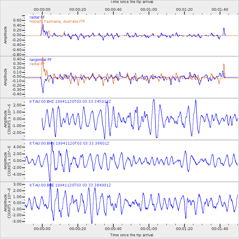
TAU Hobart, Tasmania, Australia - Earthquake Result Viewer
*The percent match for this event was below the threshold and hence no stack was calculated.
| Earthquake location: |
Solomon Islands |
| Earthquake latitude/longitude: |
-9.8/159.7 |
| Earthquake time(UTC): |
1994/11/20 (324) 02:57:15 GMT |
| Earthquake Depth: |
24 km |
| Earthquake Magnitude: |
5.7 MB, 5.5 MS, 5.3 UNKNOWN, 5.8 MW |
| Earthquake Catalog/Contributor: |
WHDF/NEIC |
|
| Network: |
II Global Seismograph Network (GSN - IRIS/IDA) |
| Station: |
TAU Hobart, Tasmania, Australia |
| Lat/Lon: |
42.91 S/147.32 E |
| Elevation: |
132 m |
|
| Distance: |
34.7 deg |
| Az: |
196.027 deg |
| Baz: |
21.74 deg |
| Ray Param: |
$rayparam |
*The percent match for this event was below the threshold and hence was not used in the summary stack. |
|
| Radial Match: |
62.93775 % |
| Radial Bump: |
400 |
| Transverse Match: |
46.7124 % |
| Transverse Bump: |
400 |
| SOD ConfigId: |
4480 |
| Insert Time: |
2010-03-02 00:37:42.144 +0000 |
| GWidth: |
2.5 |
| Max Bumps: |
400 |
| Tol: |
0.001 |
|
Signal To Noise
| Channel | StoN | STA | LTA |
| II:TAU:00:BHN:19941120T03:03:33.36601Z | 2.6291664 | 2.433865E-6 | 9.2571736E-7 |
| II:TAU:00:BHE:19941120T03:03:33.384991Z | 2.2155597 | 1.1903786E-6 | 5.372812E-7 |
| II:TAU:00:BHZ:19941120T03:03:33.345013Z | 1.0780088 | 1.0433808E-6 | 9.678779E-7 |
| Arrivals |
| Ps | |
| PpPs | |
| PsPs/PpSs | |


