You are here: Home > Network List > II - Global Seismograph Network (GSN - IRIS/IDA) Stations List
> Station TAU Hobart, Tasmania, Australia > Earthquake Result Viewer
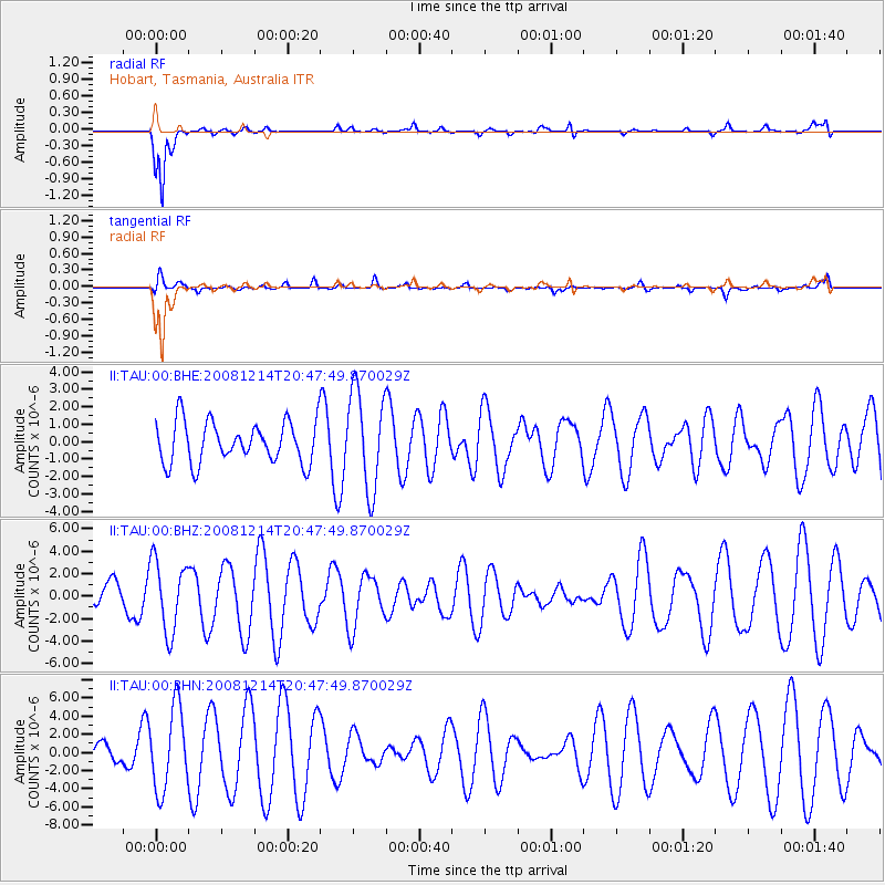
TAU Hobart, Tasmania, Australia - Earthquake Result Viewer
*The percent match for this event was below the threshold and hence no stack was calculated.
| Earthquake location: |
East Of South Sandwich Islands |
| Earthquake latitude/longitude: |
-60.1/-18.8 |
| Earthquake time(UTC): |
2008/12/14 (349) 20:36:29 GMT |
| Earthquake Depth: |
10 km |
| Earthquake Magnitude: |
5.5 MW, 5.2 MS, 5.3 MB |
| Earthquake Catalog/Contributor: |
WHDF/NEIC |
|
| Network: |
II Global Seismograph Network (GSN - IRIS/IDA) |
| Station: |
TAU Hobart, Tasmania, Australia |
| Lat/Lon: |
42.91 S/147.32 E |
| Elevation: |
132 m |
|
| Distance: |
76.7 deg |
| Az: |
169.539 deg |
| Baz: |
187.117 deg |
| Ray Param: |
$rayparam |
*The percent match for this event was below the threshold and hence was not used in the summary stack. |
|
| Radial Match: |
83.37807 % |
| Radial Bump: |
270 |
| Transverse Match: |
46.926434 % |
| Transverse Bump: |
321 |
| SOD ConfigId: |
2658 |
| Insert Time: |
2010-03-02 00:37:44.557 +0000 |
| GWidth: |
2.5 |
| Max Bumps: |
400 |
| Tol: |
0.001 |
|
Signal To Noise
| Channel | StoN | STA | LTA |
| II:TAU:00:BHZ:20081214T20:47:49.870029Z | 1.0864202 | 3.171083E-6 | 2.9188368E-6 |
| II:TAU:00:BHN:20081214T20:47:49.870029Z | 2.4652162 | 4.5160837E-6 | 1.831922E-6 |
| II:TAU:00:BHE:20081214T20:47:49.870029Z | 2.3773918 | 2.8239126E-6 | 1.1878195E-6 |
| Arrivals |
| Ps | |
| PpPs | |
| PsPs/PpSs | |


