You are here: Home > Network List > II - Global Seismograph Network (GSN - IRIS/IDA) Stations List
> Station TAU Hobart, Tasmania, Australia > Earthquake Result Viewer
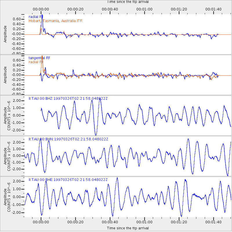
TAU Hobart, Tasmania, Australia - Earthquake Result Viewer
*The percent match for this event was below the threshold and hence no stack was calculated.
| Earthquake location: |
Rat Islands, Aleutian Islands |
| Earthquake latitude/longitude: |
51.3/179.5 |
| Earthquake time(UTC): |
1997/03/26 (085) 02:08:57 GMT |
| Earthquake Depth: |
33 km |
| Earthquake Magnitude: |
6.0 MB, 6.5 MS, 6.7 UNKNOWN, 6.3 ML |
| Earthquake Catalog/Contributor: |
WHDF/NEIC |
|
| Network: |
II Global Seismograph Network (GSN - IRIS/IDA) |
| Station: |
TAU Hobart, Tasmania, Australia |
| Lat/Lon: |
42.91 S/147.32 E |
| Elevation: |
132 m |
|
| Distance: |
97.9 deg |
| Az: |
203.29 deg |
| Baz: |
19.757 deg |
| Ray Param: |
$rayparam |
*The percent match for this event was below the threshold and hence was not used in the summary stack. |
|
| Radial Match: |
64.04231 % |
| Radial Bump: |
400 |
| Transverse Match: |
57.548855 % |
| Transverse Bump: |
400 |
| SOD ConfigId: |
4480 |
| Insert Time: |
2010-03-02 00:38:02.368 +0000 |
| GWidth: |
2.5 |
| Max Bumps: |
400 |
| Tol: |
0.001 |
|
Signal To Noise
| Channel | StoN | STA | LTA |
| II:TAU:00:BHN:19970326T02:21:58.048022Z | 2.1828458 | 1.8850467E-6 | 8.6357295E-7 |
| II:TAU:00:BHE:19970326T02:21:58.048022Z | 2.014311 | 1.3902653E-6 | 6.9019393E-7 |
| II:TAU:00:BHZ:19970326T02:21:58.048022Z | 2.2387333 | 1.8352569E-6 | 8.197747E-7 |
| Arrivals |
| Ps | |
| PpPs | |
| PsPs/PpSs | |


