You are here: Home > Network List > II - Global Seismograph Network (GSN - IRIS/IDA) Stations List
> Station TAU Hobart, Tasmania, Australia > Earthquake Result Viewer
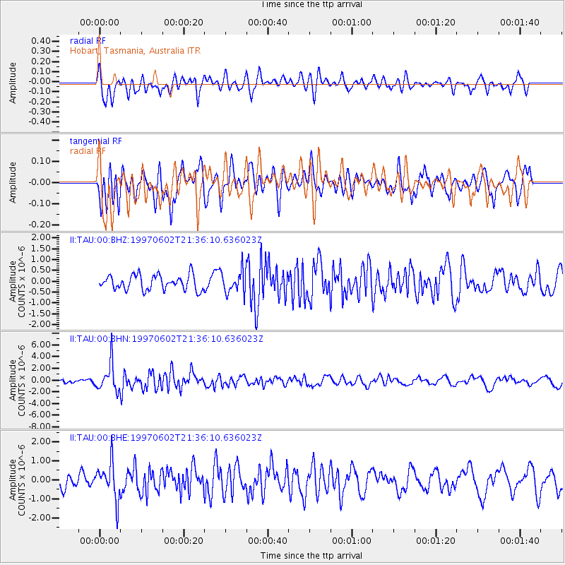
TAU Hobart, Tasmania, Australia - Earthquake Result Viewer
*The percent match for this event was below the threshold and hence no stack was calculated.
| Earthquake location: |
South Sandwich Islands Region |
| Earthquake latitude/longitude: |
-57.8/-25.5 |
| Earthquake time(UTC): |
1997/06/02 (153) 21:24:38 GMT |
| Earthquake Depth: |
33 km |
| Earthquake Magnitude: |
5.9 MB, 5.8 MS, 6.1 UNKNOWN, 6.1 MW |
| Earthquake Catalog/Contributor: |
WHDF/NEIC |
|
| Network: |
II Global Seismograph Network (GSN - IRIS/IDA) |
| Station: |
TAU Hobart, Tasmania, Australia |
| Lat/Lon: |
42.91 S/147.32 E |
| Elevation: |
132 m |
|
| Distance: |
79.5 deg |
| Az: |
174.616 deg |
| Baz: |
183.924 deg |
| Ray Param: |
$rayparam |
*The percent match for this event was below the threshold and hence was not used in the summary stack. |
|
| Radial Match: |
70.55036 % |
| Radial Bump: |
400 |
| Transverse Match: |
55.19868 % |
| Transverse Bump: |
400 |
| SOD ConfigId: |
4480 |
| Insert Time: |
2010-03-02 00:38:22.163 +0000 |
| GWidth: |
2.5 |
| Max Bumps: |
400 |
| Tol: |
0.001 |
|
Signal To Noise
| Channel | StoN | STA | LTA |
| II:TAU:00:BHN:19970602T21:36:10.636023Z | 5.745665 | 2.4464214E-6 | 4.257856E-7 |
| II:TAU:00:BHE:19970602T21:36:10.636023Z | 2.9922867 | 9.969704E-7 | 3.3318008E-7 |
| II:TAU:00:BHZ:19970602T21:36:10.636023Z | 1.5046891 | 5.1078104E-7 | 3.3945952E-7 |
| Arrivals |
| Ps | |
| PpPs | |
| PsPs/PpSs | |


