You are here: Home > Network List > II - Global Seismograph Network (GSN - IRIS/IDA) Stations List
> Station TAU Hobart, Tasmania, Australia > Earthquake Result Viewer
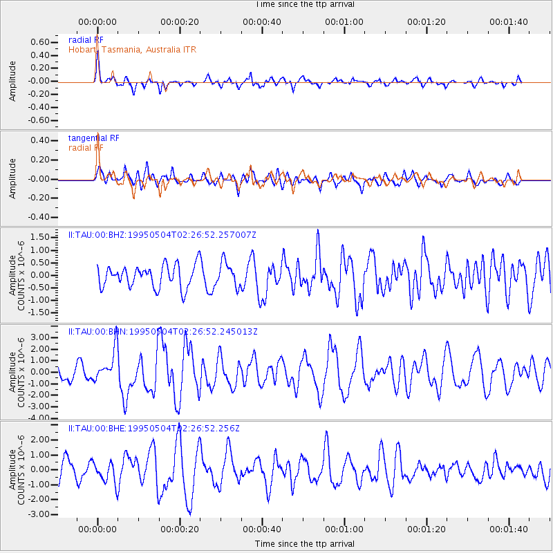
TAU Hobart, Tasmania, Australia - Earthquake Result Viewer
*The percent match for this event was below the threshold and hence no stack was calculated.
| Earthquake location: |
Halmahera, Indonesia |
| Earthquake latitude/longitude: |
1.9/128.5 |
| Earthquake time(UTC): |
1995/05/04 (124) 02:18:51 GMT |
| Earthquake Depth: |
55 km |
| Earthquake Magnitude: |
6.0 MB, 6.0 MS, 6.1 UNKNOWN, 6.1 MW |
| Earthquake Catalog/Contributor: |
WHDF/NEIC |
|
| Network: |
II Global Seismograph Network (GSN - IRIS/IDA) |
| Station: |
TAU Hobart, Tasmania, Australia |
| Lat/Lon: |
42.91 S/147.32 E |
| Elevation: |
132 m |
|
| Distance: |
47.7 deg |
| Az: |
161.294 deg |
| Baz: |
334.132 deg |
| Ray Param: |
$rayparam |
*The percent match for this event was below the threshold and hence was not used in the summary stack. |
|
| Radial Match: |
69.02239 % |
| Radial Bump: |
400 |
| Transverse Match: |
68.8592 % |
| Transverse Bump: |
400 |
| SOD ConfigId: |
4480 |
| Insert Time: |
2010-03-02 00:38:24.282 +0000 |
| GWidth: |
2.5 |
| Max Bumps: |
400 |
| Tol: |
0.001 |
|
Signal To Noise
| Channel | StoN | STA | LTA |
| II:TAU:00:BHN:19950504T02:26:52.245013Z | 1.8204527 | 1.4630536E-6 | 8.0367573E-7 |
| II:TAU:00:BHE:19950504T02:26:52.256Z | 1.3725109 | 7.3737914E-7 | 5.372483E-7 |
| II:TAU:00:BHZ:19950504T02:26:52.257007Z | 1.1125255 | 4.870664E-7 | 4.378025E-7 |
| Arrivals |
| Ps | |
| PpPs | |
| PsPs/PpSs | |


