You are here: Home > Network List > II - Global Seismograph Network (GSN - IRIS/IDA) Stations List
> Station TAU Hobart, Tasmania, Australia > Earthquake Result Viewer
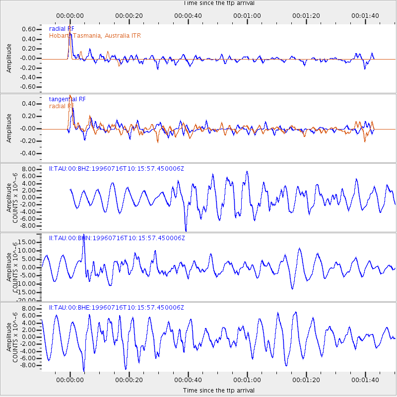
TAU Hobart, Tasmania, Australia - Earthquake Result Viewer
*The percent match for this event was below the threshold and hence no stack was calculated.
| Earthquake location: |
Minahassa Peninsula, Sulawesi |
| Earthquake latitude/longitude: |
1.0/120.3 |
| Earthquake time(UTC): |
1996/07/16 (198) 10:07:36 GMT |
| Earthquake Depth: |
33 km |
| Earthquake Magnitude: |
6.0 MB, 6.4 MS, 6.6 UNKNOWN, 6.6 MW |
| Earthquake Catalog/Contributor: |
WHDF/NEIC |
|
| Network: |
II Global Seismograph Network (GSN - IRIS/IDA) |
| Station: |
TAU Hobart, Tasmania, Australia |
| Lat/Lon: |
42.91 S/147.32 E |
| Elevation: |
132 m |
|
| Distance: |
50.0 deg |
| Az: |
154.144 deg |
| Baz: |
323.594 deg |
| Ray Param: |
$rayparam |
*The percent match for this event was below the threshold and hence was not used in the summary stack. |
|
| Radial Match: |
89.29594 % |
| Radial Bump: |
400 |
| Transverse Match: |
39.534748 % |
| Transverse Bump: |
400 |
| SOD ConfigId: |
4480 |
| Insert Time: |
2010-03-02 00:38:32.025 +0000 |
| GWidth: |
2.5 |
| Max Bumps: |
400 |
| Tol: |
0.001 |
|
Signal To Noise
| Channel | StoN | STA | LTA |
| II:TAU:00:BHN:19960716T10:15:57.450006Z | 1.8992568 | 7.1089E-6 | 3.7429902E-6 |
| II:TAU:00:BHE:19960716T10:15:57.450006Z | 1.1996387 | 4.062983E-6 | 3.3868387E-6 |
| II:TAU:00:BHZ:19960716T10:15:57.450006Z | 0.6526123 | 1.4058982E-6 | 2.1542623E-6 |
| Arrivals |
| Ps | |
| PpPs | |
| PsPs/PpSs | |


