You are here: Home > Network List > TA - USArray Transportable Network (new EarthScope stations) Stations List
> Station W41B Gary Mavity, Velonia, AR, USA > Earthquake Result Viewer
W41B Gary Mavity, Velonia, AR, USA - Earthquake Result Viewer
| Earthquake location: |
Northern Algeria |
| Earthquake latitude/longitude: |
36.9/3.2 |
| Earthquake time(UTC): |
2014/08/01 (213) 04:11:16 GMT |
| Earthquake Depth: |
10 km |
| Earthquake Magnitude: |
5.6 MWP |
| Earthquake Catalog/Contributor: |
NEIC PDE/NEIC COMCAT |
|
| Network: |
TA USArray Transportable Network (new EarthScope stations) |
| Station: |
W41B Gary Mavity, Velonia, AR, USA |
| Lat/Lon: |
35.17 N/92.25 W |
| Elevation: |
95 m |
|
| Distance: |
73.7 deg |
| Az: |
301.822 deg |
| Baz: |
56.301 deg |
| Ray Param: |
0.052823283 |
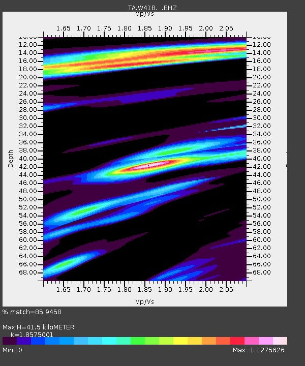
| Estimated Moho Depth: |
41.5 km |
| Estimated Crust Vp/Vs: |
1.86 |
| Assumed Crust Vp: |
6.498 km/s |
| Estimated Crust Vs: |
3.498 km/s |
| Estimated Crust Poisson's Ratio: |
0.30 |
|
| Radial Match: |
85.9458 % |
| Radial Bump: |
400 |
| Transverse Match: |
58.210274 % |
| Transverse Bump: |
400 |
| SOD ConfigId: |
769524 |
| Insert Time: |
2014-08-15 05:14:54.689 +0000 |
| GWidth: |
2.5 |
| Max Bumps: |
400 |
| Tol: |
0.001 |
|

Signal To Noise
| Channel | StoN | STA | LTA |
| TA:W41B: :BHZ:20140801T04:22:19.549973Z | 2.0412023 | 1.8010778E-7 | 8.823613E-8 |
| TA:W41B: :BHN:20140801T04:22:19.549973Z | 1.2967274 | 5.1255473E-8 | 3.9526793E-8 |
| TA:W41B: :BHE:20140801T04:22:19.549973Z | 2.5785215 | 7.146325E-8 | 2.7714815E-8 |
| Arrivals |
| Ps | 5.7 SECOND |
| PpPs | 18 SECOND |
| PsPs/PpSs | 23 SECOND |


