You are here: Home > Network List > II - Global Seismograph Network (GSN - IRIS/IDA) Stations List
> Station TAU Hobart, Tasmania, Australia > Earthquake Result Viewer
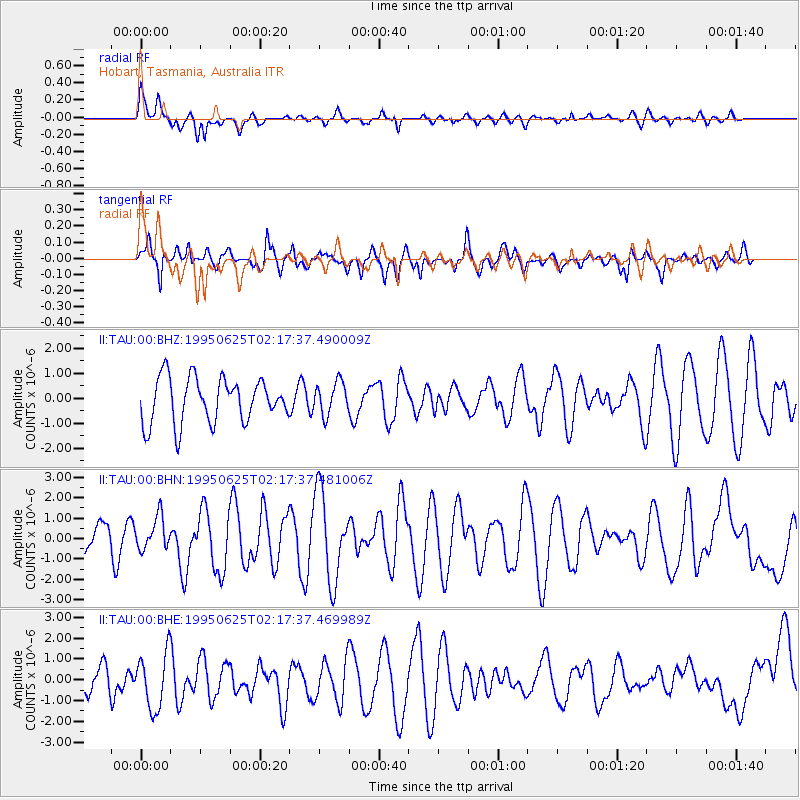
TAU Hobart, Tasmania, Australia - Earthquake Result Viewer
*The percent match for this event was below the threshold and hence no stack was calculated.
| Earthquake location: |
New Ireland Region, P.N.G. |
| Earthquake latitude/longitude: |
-3.3/150.4 |
| Earthquake time(UTC): |
1995/06/25 (176) 02:10:41 GMT |
| Earthquake Depth: |
45 km |
| Earthquake Magnitude: |
5.5 MB, 6.3 MS, 6.2 UNKNOWN, 6.2 MW |
| Earthquake Catalog/Contributor: |
WHDF/NEIC |
|
| Network: |
II Global Seismograph Network (GSN - IRIS/IDA) |
| Station: |
TAU Hobart, Tasmania, Australia |
| Lat/Lon: |
42.91 S/147.32 E |
| Elevation: |
132 m |
|
| Distance: |
39.6 deg |
| Az: |
183.513 deg |
| Baz: |
4.777 deg |
| Ray Param: |
$rayparam |
*The percent match for this event was below the threshold and hence was not used in the summary stack. |
|
| Radial Match: |
51.46213 % |
| Radial Bump: |
354 |
| Transverse Match: |
66.97809 % |
| Transverse Bump: |
393 |
| SOD ConfigId: |
4480 |
| Insert Time: |
2010-03-02 00:38:34.914 +0000 |
| GWidth: |
2.5 |
| Max Bumps: |
400 |
| Tol: |
0.001 |
|
Signal To Noise
| Channel | StoN | STA | LTA |
| II:TAU:00:BHN:19950625T02:17:37.481006Z | 1.3461947 | 8.082465E-7 | 6.003935E-7 |
| II:TAU:00:BHE:19950625T02:17:37.469989Z | 1.6287186 | 1.3361101E-6 | 8.203443E-7 |
| II:TAU:00:BHZ:19950625T02:17:37.490009Z | 0.725333 | 6.4899257E-7 | 8.947512E-7 |
| Arrivals |
| Ps | |
| PpPs | |
| PsPs/PpSs | |


