You are here: Home > Network List > II - Global Seismograph Network (GSN - IRIS/IDA) Stations List
> Station TAU Hobart, Tasmania, Australia > Earthquake Result Viewer
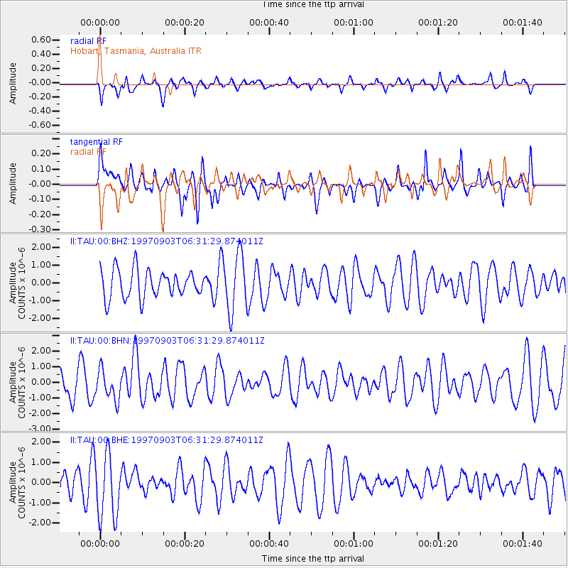
TAU Hobart, Tasmania, Australia - Earthquake Result Viewer
*The percent match for this event was below the threshold and hence no stack was calculated.
| Earthquake location: |
Pacific-Antarctic Ridge |
| Earthquake latitude/longitude: |
-55.2/-129.0 |
| Earthquake time(UTC): |
1997/09/03 (246) 06:22:44 GMT |
| Earthquake Depth: |
10 km |
| Earthquake Magnitude: |
5.1 MB, 6.0 MS, 6.1 UNKNOWN, 6.0 MW |
| Earthquake Catalog/Contributor: |
WHDF/NEIC |
|
| Network: |
II Global Seismograph Network (GSN - IRIS/IDA) |
| Station: |
TAU Hobart, Tasmania, Australia |
| Lat/Lon: |
42.91 S/147.32 E |
| Elevation: |
132 m |
|
| Distance: |
53.0 deg |
| Az: |
246.148 deg |
| Baz: |
134.451 deg |
| Ray Param: |
$rayparam |
*The percent match for this event was below the threshold and hence was not used in the summary stack. |
|
| Radial Match: |
49.632565 % |
| Radial Bump: |
367 |
| Transverse Match: |
43.612297 % |
| Transverse Bump: |
392 |
| SOD ConfigId: |
4480 |
| Insert Time: |
2010-03-02 00:38:37.828 +0000 |
| GWidth: |
2.5 |
| Max Bumps: |
400 |
| Tol: |
0.001 |
|
Signal To Noise
| Channel | StoN | STA | LTA |
| II:TAU:00:BHN:19970903T06:31:29.874011Z | 0.82732403 | 9.599606E-7 | 1.1603199E-6 |
| II:TAU:00:BHE:19970903T06:31:29.874011Z | 2.5588942 | 1.5913503E-6 | 6.2188985E-7 |
| II:TAU:00:BHZ:19970903T06:31:29.874011Z | 2.1332402 | 1.6367677E-6 | 7.672683E-7 |
| Arrivals |
| Ps | |
| PpPs | |
| PsPs/PpSs | |


