You are here: Home > Network List > II - Global Seismograph Network (GSN - IRIS/IDA) Stations List
> Station TAU Hobart, Tasmania, Australia > Earthquake Result Viewer
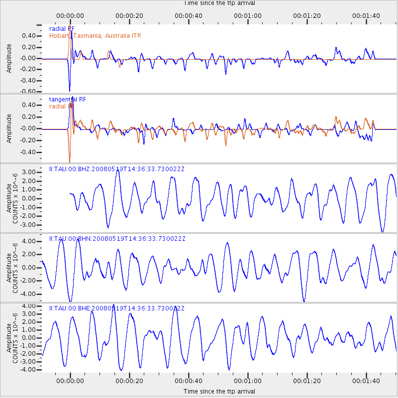
TAU Hobart, Tasmania, Australia - Earthquake Result Viewer
*The percent match for this event was below the threshold and hence no stack was calculated.
| Earthquake location: |
Northern Sumatra, Indonesia |
| Earthquake latitude/longitude: |
1.6/99.1 |
| Earthquake time(UTC): |
2008/05/19 (140) 14:26:45 GMT |
| Earthquake Depth: |
10 km |
| Earthquake Magnitude: |
5.8 MB, 6.0 MS, 6.0 MW, 6.0 MW |
| Earthquake Catalog/Contributor: |
WHDF/NEIC |
|
| Network: |
II Global Seismograph Network (GSN - IRIS/IDA) |
| Station: |
TAU Hobart, Tasmania, Australia |
| Lat/Lon: |
42.91 S/147.32 E |
| Elevation: |
132 m |
|
| Distance: |
61.9 deg |
| Az: |
141.653 deg |
| Baz: |
302.422 deg |
| Ray Param: |
$rayparam |
*The percent match for this event was below the threshold and hence was not used in the summary stack. |
|
| Radial Match: |
35.74719 % |
| Radial Bump: |
400 |
| Transverse Match: |
60.88218 % |
| Transverse Bump: |
367 |
| SOD ConfigId: |
2504 |
| Insert Time: |
2010-03-02 00:38:54.977 +0000 |
| GWidth: |
2.5 |
| Max Bumps: |
400 |
| Tol: |
0.001 |
|
Signal To Noise
| Channel | StoN | STA | LTA |
| II:TAU:00:BHN:20080519T14:36:33.730022Z | 2.0769508 | 3.3422004E-6 | 1.6091861E-6 |
| II:TAU:00:BHE:20080519T14:36:33.730022Z | 1.0183333 | 1.7928004E-6 | 1.7605241E-6 |
| II:TAU:00:BHZ:20080519T14:36:33.730022Z | 1.0886451 | 1.5682062E-6 | 1.4405119E-6 |
| Arrivals |
| Ps | |
| PpPs | |
| PsPs/PpSs | |


