You are here: Home > Network List > TA - USArray Transportable Network (new EarthScope stations) Stations List
> Station I61A Oroboro, Fairlee, VT, USA > Earthquake Result Viewer
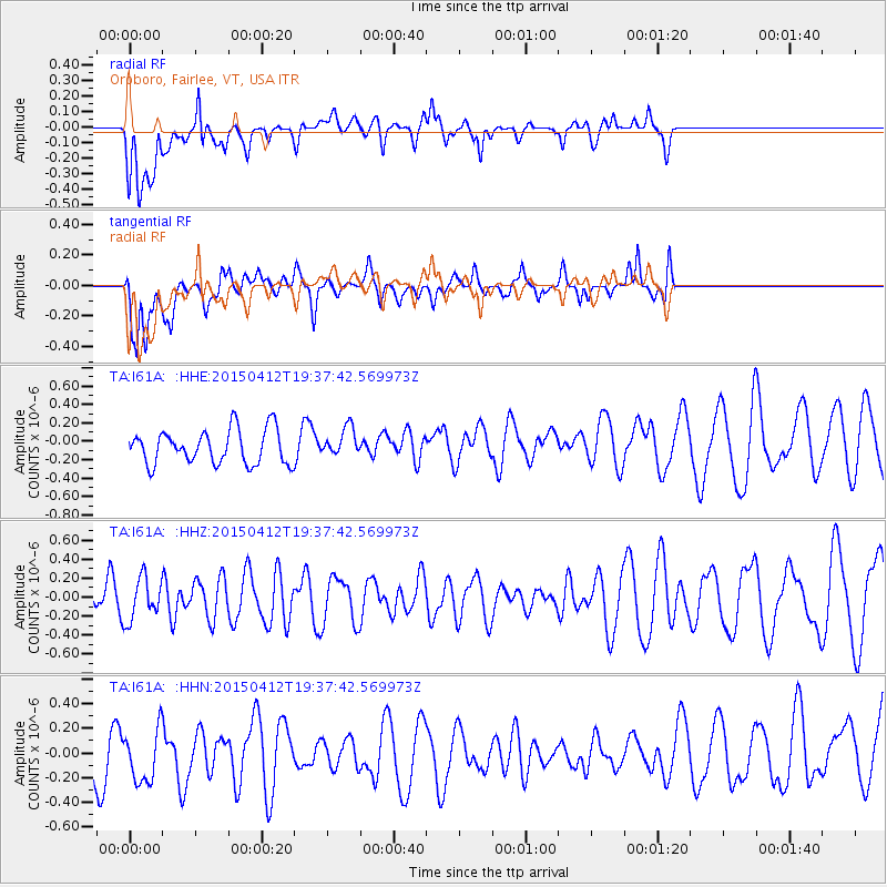
I61A Oroboro, Fairlee, VT, USA - Earthquake Result Viewer
*The percent match for this event was below the threshold and hence no stack was calculated.
| Earthquake location: |
Off East Coast Of Honshu, Japan |
| Earthquake latitude/longitude: |
37.2/143.9 |
| Earthquake time(UTC): |
2015/04/12 (102) 19:25:01 GMT |
| Earthquake Depth: |
12 km |
| Earthquake Magnitude: |
5.2 MW, 5.7 mb, 4.8 MS |
| Earthquake Catalog/Contributor: |
ISC/ISC |
|
| Network: |
TA USArray Transportable Network (new EarthScope stations) |
| Station: |
I61A Oroboro, Fairlee, VT, USA |
| Lat/Lon: |
43.93 N/72.21 W |
| Elevation: |
287 m |
|
| Distance: |
92.9 deg |
| Az: |
25.216 deg |
| Baz: |
331.911 deg |
| Ray Param: |
$rayparam |
*The percent match for this event was below the threshold and hence was not used in the summary stack. |
|
| Radial Match: |
40.771397 % |
| Radial Bump: |
400 |
| Transverse Match: |
55.187443 % |
| Transverse Bump: |
400 |
| SOD ConfigId: |
7422571 |
| Insert Time: |
2019-04-18 04:10:53.505 +0000 |
| GWidth: |
2.5 |
| Max Bumps: |
400 |
| Tol: |
0.001 |
|
Signal To Noise
| Channel | StoN | STA | LTA |
| TA:I61A: :HHZ:20150412T19:37:42.569973Z | 1.1115506 | 2.2272292E-7 | 2.0037137E-7 |
| TA:I61A: :HHN:20150412T19:37:42.569973Z | 1.1257662 | 2.4945848E-7 | 2.2158996E-7 |
| TA:I61A: :HHE:20150412T19:37:42.569973Z | 0.832644 | 1.5367822E-7 | 1.8456653E-7 |
| Arrivals |
| Ps | |
| PpPs | |
| PsPs/PpSs | |


