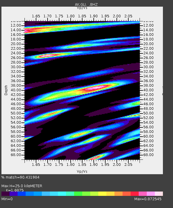
GLI Glacier Island - Earthquake Result Viewer

Earthquake location: E. Caroline Islands, Micronesia
Earthquake latitude/longitude: 0.8/146.1
Earthquake time(UTC): 2014/08/03 (215) 00:22:03 GMT
Earthquake Depth: 11 km
Earthquake Magnitude: 6.9 MWW, 6.8 MWB, 6.9 MWC, 7.2 MI
Earthquake Catalog/Contributor: NEIC PDE/NEIC COMCAT
Network: AK Alaska Regional Network
Station: GLI Glacier Island
Lat/Lon: 60.88 N/147.09 W
Elevation: 430 m
Distance: 78.1 deg
Az: 27.341 deg
Baz: 249.861 deg
Ray Param: 0.049851798
Estimated Moho Depth: 25.0 km
Estimated Crust Vp/Vs: 1.69
Assumed Crust Vp: 6.566 km/s
Estimated Crust Vs: 3.891 km/s
Estimated Crust Poisson's Ratio: 0.23
Radial Match: 90.431984 %
Radial Bump: 400
Transverse Match: 89.36577 %
Transverse Bump: 400
SOD ConfigId: 769524
Insert Time: 2014-08-17 00:35:11.482 +0000
GWidth: 2.5
Max Bumps: 400
Tol: 0.001

Signal To Noise

ChannelStoNSTALTA
AK:GLI: :BHZ:20140803T00:33:30.907998Z11.44118.9358645E-77.810319E-8
AK:GLI: :BHN:20140803T00:33:30.907998Z3.46182632.7064448E-77.817968E-8
AK:GLI: :BHE:20140803T00:33:30.907998Z9.5410155.7717574E-76.0494166E-8
Arrivals
Ps2.7 SECOND
PpPs9.9 SECOND
PsPs/PpSs13 SECOND