You are here: Home > Network List > II - Global Seismograph Network (GSN - IRIS/IDA) Stations List
> Station COCO West Island, Cocos (Keeling) Islands > Earthquake Result Viewer
COCO West Island, Cocos (Keeling) Islands - Earthquake Result Viewer
| Earthquake location: |
Hokkaido, Japan Region |
| Earthquake latitude/longitude: |
43.0/145.1 |
| Earthquake time(UTC): |
2004/11/28 (333) 18:32:14 GMT |
| Earthquake Depth: |
39 km |
| Earthquake Magnitude: |
6.4 MB, 6.7 MS, 7.0 MW, 7.0 MW |
| Earthquake Catalog/Contributor: |
WHDF/NEIC |
|
| Network: |
II Global Seismograph Network (GSN - IRIS/IDA) |
| Station: |
COCO West Island, Cocos (Keeling) Islands |
| Lat/Lon: |
12.19 S/96.83 E |
| Elevation: |
1.0 m |
|
| Distance: |
70.4 deg |
| Az: |
230.76 deg |
| Baz: |
35.527 deg |
| Ray Param: |
0.05491088 |
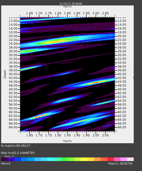
| Estimated Moho Depth: |
62.0 km |
| Estimated Crust Vp/Vs: |
1.70 |
| Assumed Crust Vp: |
4.24 km/s |
| Estimated Crust Vs: |
2.494 km/s |
| Estimated Crust Poisson's Ratio: |
0.24 |
|
| Radial Match: |
90.49107 % |
| Radial Bump: |
384 |
| Transverse Match: |
87.226875 % |
| Transverse Bump: |
368 |
| SOD ConfigId: |
2459 |
| Insert Time: |
2010-03-02 00:39:03.376 +0000 |
| GWidth: |
2.5 |
| Max Bumps: |
400 |
| Tol: |
0.001 |
|
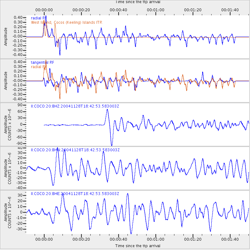
Signal To Noise
| Channel | StoN | STA | LTA |
| II:COCO:20:BHN:20041128T18:42:53.583003Z | 4.632802 | 1.1775429E-5 | 2.541751E-6 |
| II:COCO:20:BHE:20041128T18:42:53.583003Z | 4.199967 | 7.6540755E-6 | 1.8224132E-6 |
| II:COCO:20:BHZ:20041128T18:42:53.583003Z | 25.974304 | 3.1496493E-5 | 1.212602E-6 |
| Arrivals |
| Ps | 10 SECOND |
| PpPs | 39 SECOND |
| PsPs/PpSs | 49 SECOND |


