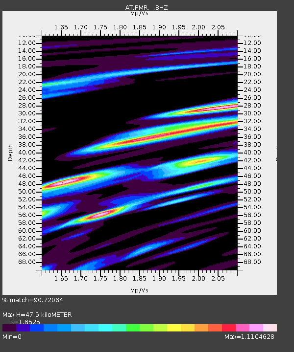
PMR Palmer, Alaska - Earthquake Result Viewer

Earthquake location: E. Caroline Islands, Micronesia
Earthquake latitude/longitude: 0.8/146.1
Earthquake time(UTC): 2014/08/03 (215) 00:22:03 GMT
Earthquake Depth: 11 km
Earthquake Magnitude: 6.9 MWW, 6.8 MWB, 6.9 MWC, 7.2 MI
Earthquake Catalog/Contributor: NEIC PDE/NEIC COMCAT
Network: AT Alaska Tsunami Warning Seismic System
Station: PMR Palmer, Alaska
Lat/Lon: 61.59 N/149.13 W
Elevation: 100 m
Distance: 77.5 deg
Az: 26.295 deg
Baz: 247.857 deg
Ray Param: 0.05030209
Estimated Moho Depth: 47.5 km
Estimated Crust Vp/Vs: 1.65
Assumed Crust Vp: 6.566 km/s
Estimated Crust Vs: 3.973 km/s
Estimated Crust Poisson's Ratio: 0.21
Radial Match: 90.72064 %
Radial Bump: 400
Transverse Match: 89.66838 %
Transverse Bump: 400
SOD ConfigId: 769524
Insert Time: 2014-08-17 00:39:29.447 +0000
GWidth: 2.5
Max Bumps: 400
Tol: 0.001

Signal To Noise

ChannelStoNSTALTA
AT:PMR: :BHZ:20140803T00:33:27.240029Z16.7493861.0384618E-66.2E-8
AT:PMR: :BHN:20140803T00:33:27.240029Z2.42041021.2529382E-75.1765532E-8
AT:PMR: :BHE:20140803T00:33:27.240029Z10.6414034.6340148E-74.354703E-8
Arrivals
Ps4.9 SECOND
PpPs19 SECOND
PsPs/PpSs23 SECOND