You are here: Home > Network List > II - Global Seismograph Network (GSN - IRIS/IDA) Stations List
> Station COCO West Island, Cocos (Keeling) Islands > Earthquake Result Viewer
COCO West Island, Cocos (Keeling) Islands - Earthquake Result Viewer
| Earthquake location: |
Afghanistan-Tajikistan Bord Reg. |
| Earthquake latitude/longitude: |
36.5/71.0 |
| Earthquake time(UTC): |
2004/04/05 (096) 21:24:04 GMT |
| Earthquake Depth: |
187 km |
| Earthquake Magnitude: |
6.4 MB, 6.6 MW, 6.5 MW |
| Earthquake Catalog/Contributor: |
WHDF/NEIC |
|
| Network: |
II Global Seismograph Network (GSN - IRIS/IDA) |
| Station: |
COCO West Island, Cocos (Keeling) Islands |
| Lat/Lon: |
12.19 S/96.83 E |
| Elevation: |
1.0 m |
|
| Distance: |
54.2 deg |
| Az: |
148.349 deg |
| Baz: |
334.382 deg |
| Ray Param: |
0.064958155 |
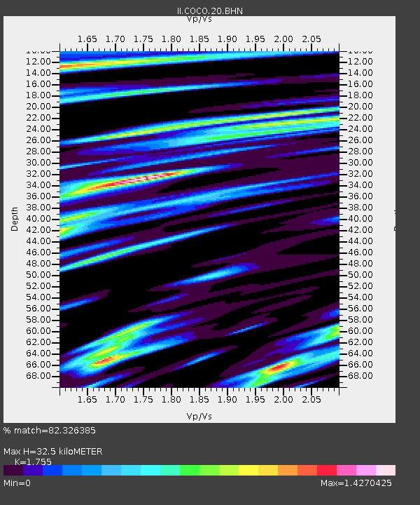
| Estimated Moho Depth: |
32.5 km |
| Estimated Crust Vp/Vs: |
1.75 |
| Assumed Crust Vp: |
4.24 km/s |
| Estimated Crust Vs: |
2.416 km/s |
| Estimated Crust Poisson's Ratio: |
0.26 |
|
| Radial Match: |
82.326385 % |
| Radial Bump: |
400 |
| Transverse Match: |
80.3962 % |
| Transverse Bump: |
400 |
| SOD ConfigId: |
2459 |
| Insert Time: |
2010-03-02 00:39:10.164 +0000 |
| GWidth: |
2.5 |
| Max Bumps: |
400 |
| Tol: |
0.001 |
|
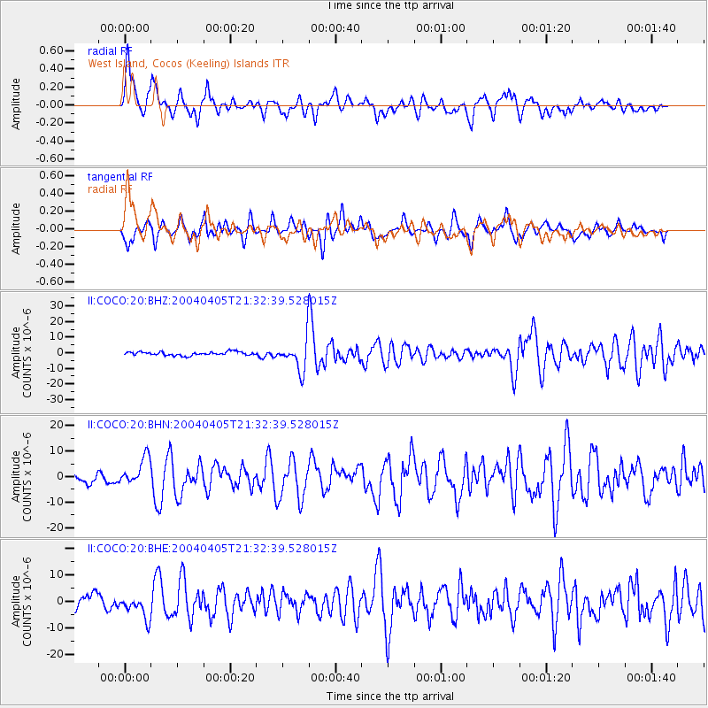
Signal To Noise
| Channel | StoN | STA | LTA |
| II:COCO:20:BHN:20040405T21:32:39.528015Z | 2.4673116 | 5.4215147E-6 | 2.197337E-6 |
| II:COCO:20:BHE:20040405T21:32:39.528015Z | 1.9699337 | 4.4622543E-6 | 2.26518E-6 |
| II:COCO:20:BHZ:20040405T21:32:39.528015Z | 8.851739 | 1.00531915E-5 | 1.1357307E-6 |
| Arrivals |
| Ps | 5.9 SECOND |
| PpPs | 21 SECOND |
| PsPs/PpSs | 27 SECOND |


