You are here: Home > Network List > II - Global Seismograph Network (GSN - IRIS/IDA) Stations List
> Station COCO West Island, Cocos (Keeling) Islands > Earthquake Result Viewer
COCO West Island, Cocos (Keeling) Islands - Earthquake Result Viewer
| Earthquake location: |
Vanuatu Islands |
| Earthquake latitude/longitude: |
-14.3/167.3 |
| Earthquake time(UTC): |
2005/02/08 (039) 14:48:21 GMT |
| Earthquake Depth: |
206 km |
| Earthquake Magnitude: |
6.1 MB, 6.8 MW, 6.7 MW |
| Earthquake Catalog/Contributor: |
WHDF/NEIC |
|
| Network: |
II Global Seismograph Network (GSN - IRIS/IDA) |
| Station: |
COCO West Island, Cocos (Keeling) Islands |
| Lat/Lon: |
12.19 S/96.83 E |
| Elevation: |
1.0 m |
|
| Distance: |
68.3 deg |
| Az: |
262.377 deg |
| Baz: |
100.604 deg |
| Ray Param: |
0.055773593 |
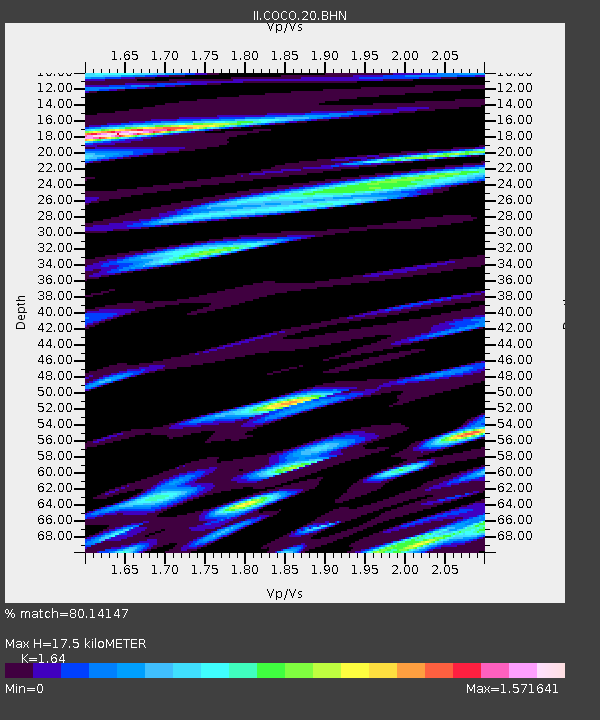
| Estimated Moho Depth: |
17.5 km |
| Estimated Crust Vp/Vs: |
1.64 |
| Assumed Crust Vp: |
4.24 km/s |
| Estimated Crust Vs: |
2.585 km/s |
| Estimated Crust Poisson's Ratio: |
0.20 |
|
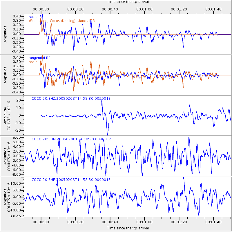
| Radial Match: |
80.14147 % |
| Radial Bump: |
400 |
| Transverse Match: |
64.71008 % |
| Transverse Bump: |
400 |
| SOD ConfigId: |
5233 |
| Insert Time: |
2010-03-02 00:39:14.322 +0000 |
| GWidth: |
2.5 |
| Max Bumps: |
400 |
| Tol: |
0.001 |
|
Signal To Noise
| Channel | StoN | STA | LTA |
| II:COCO:20:BHN:20050208T14:58:30.009001Z | 0.6929373 | 1.1213466E-6 | 1.6182511E-6 |
| II:COCO:20:BHE:20050208T14:58:30.009001Z | 1.1735866 | 1.571867E-6 | 1.3393702E-6 |
| II:COCO:20:BHZ:20050208T14:58:30.009001Z | 3.3712072 | 2.2377906E-6 | 6.63795E-7 |
| Arrivals |
| Ps | 2.7 SECOND |
| PpPs | 11 SECOND |
| PsPs/PpSs | 13 SECOND |


