You are here: Home > Network List > II - Global Seismograph Network (GSN - IRIS/IDA) Stations List
> Station COCO West Island, Cocos (Keeling) Islands > Earthquake Result Viewer
COCO West Island, Cocos (Keeling) Islands - Earthquake Result Viewer
| Earthquake location: |
Mindanao, Philippines |
| Earthquake latitude/longitude: |
5.3/123.3 |
| Earthquake time(UTC): |
2005/02/05 (036) 12:23:18 GMT |
| Earthquake Depth: |
525 km |
| Earthquake Magnitude: |
6.4 MB, 7.1 MW, 7.1 MW |
| Earthquake Catalog/Contributor: |
WHDF/NEIC |
|
| Network: |
II Global Seismograph Network (GSN - IRIS/IDA) |
| Station: |
COCO West Island, Cocos (Keeling) Islands |
| Lat/Lon: |
12.19 S/96.83 E |
| Elevation: |
1.0 m |
|
| Distance: |
31.6 deg |
| Az: |
236.47 deg |
| Baz: |
58.102 deg |
| Ray Param: |
0.07675109 |
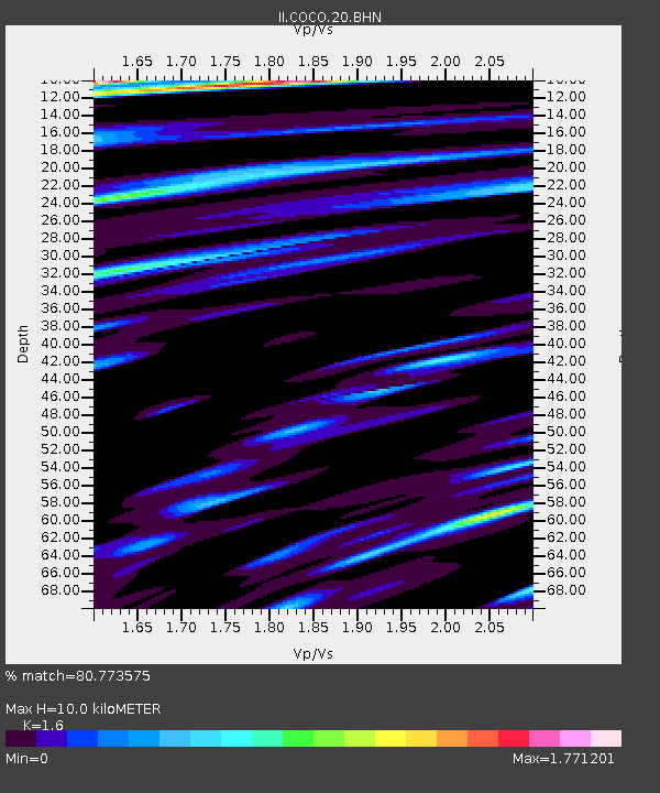
| Estimated Moho Depth: |
10.0 km |
| Estimated Crust Vp/Vs: |
1.60 |
| Assumed Crust Vp: |
4.24 km/s |
| Estimated Crust Vs: |
2.65 km/s |
| Estimated Crust Poisson's Ratio: |
0.18 |
|
| Radial Match: |
80.773575 % |
| Radial Bump: |
375 |
| Transverse Match: |
61.08972 % |
| Transverse Bump: |
377 |
| SOD ConfigId: |
5233 |
| Insert Time: |
2010-03-02 00:39:17.055 +0000 |
| GWidth: |
2.5 |
| Max Bumps: |
400 |
| Tol: |
0.001 |
|
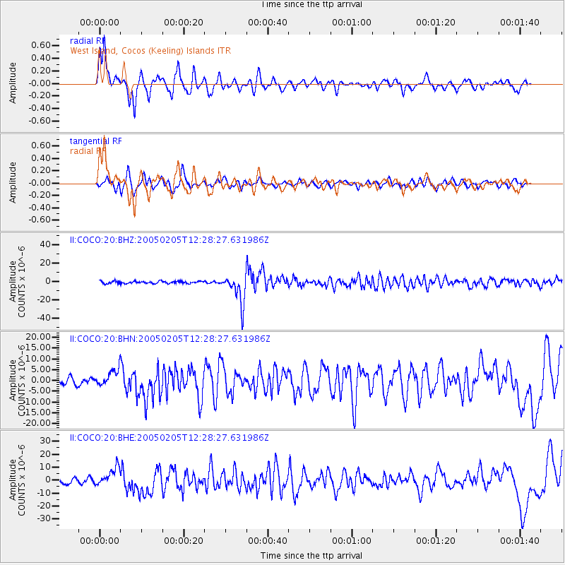
Signal To Noise
| Channel | StoN | STA | LTA |
| II:COCO:20:BHN:20050205T12:28:27.631986Z | 1.6309817 | 3.92751E-6 | 2.4080653E-6 |
| II:COCO:20:BHE:20050205T12:28:27.631986Z | 3.1063428 | 7.256501E-6 | 2.3360271E-6 |
| II:COCO:20:BHZ:20050205T12:28:27.631986Z | 13.632069 | 1.603329E-5 | 1.176145E-6 |
| Arrivals |
| Ps | 1.5 SECOND |
| PpPs | 5.9 SECOND |
| PsPs/PpSs | 7.4 SECOND |


