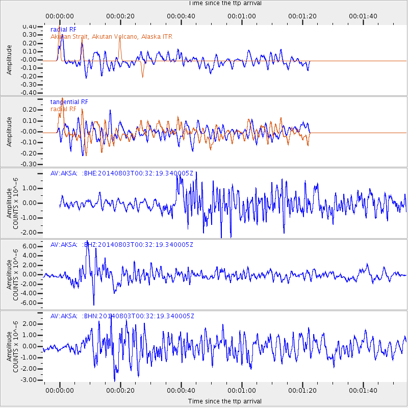
AKSA Akutan Strait, Akutan Volcano, Alaska - Earthquake Result Viewer
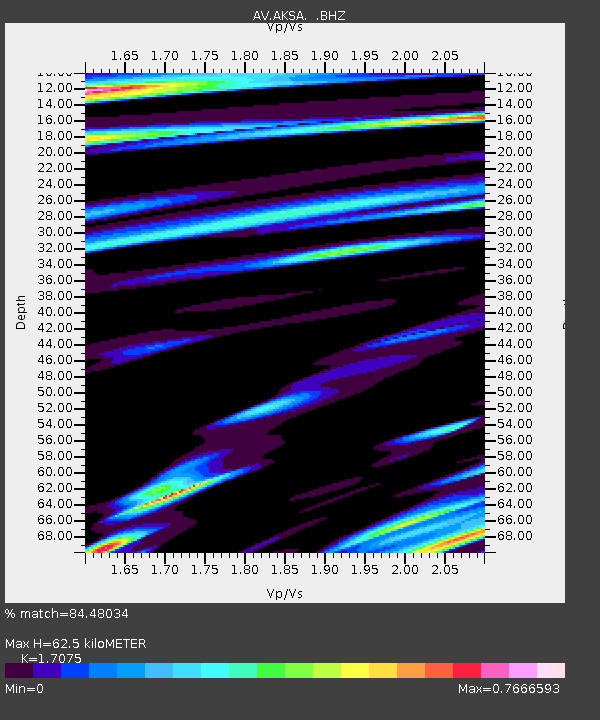
Earthquake location: E. Caroline Islands, Micronesia
Earthquake latitude/longitude: 0.8/146.1
Earthquake time(UTC): 2014/08/03 (215) 00:22:03 GMT
Earthquake Depth: 11 km
Earthquake Magnitude: 6.9 MWW, 6.8 MWB, 6.9 MWC, 7.2 MI
Earthquake Catalog/Contributor: NEIC PDE/NEIC COMCAT
Network: AV Alaska Volcano Observatory
Station: AKSA Akutan Strait, Akutan Volcano, Alaska
Lat/Lon: 54.11 N/165.70 W
Elevation: 213 m
Distance: 66.1 deg
Az: 28.664 deg
Baz: 234.541 deg
Ray Param: 0.057813272
Estimated Moho Depth: 62.5 km
Estimated Crust Vp/Vs: 1.71
Assumed Crust Vp: 5.989 km/s
Estimated Crust Vs: 3.508 km/s
Estimated Crust Poisson's Ratio: 0.24
Radial Match: 84.48034 %
Radial Bump: 400
Transverse Match: 74.47529 %
Transverse Bump: 400
SOD ConfigId: 769524
Insert Time: 2014-08-17 00:42:07.133 +0000
GWidth: 2.5
Max Bumps: 400
Tol: 0.001

Signal To Noise

ChannelStoNSTALTA
AV:AKSA: :BHZ:20140803T00:32:19.340005Z4.1312119.461041E-72.2901375E-7
AV:AKSA: :BHN:20140803T00:32:19.340005Z1.07180322.0718007E-71.9330047E-7
AV:AKSA: :BHE:20140803T00:32:19.340005Z1.42927753.3327342E-72.3317615E-7
Arrivals
Ps7.7 SECOND
PpPs27 SECOND
PsPs/PpSs35 SECOND