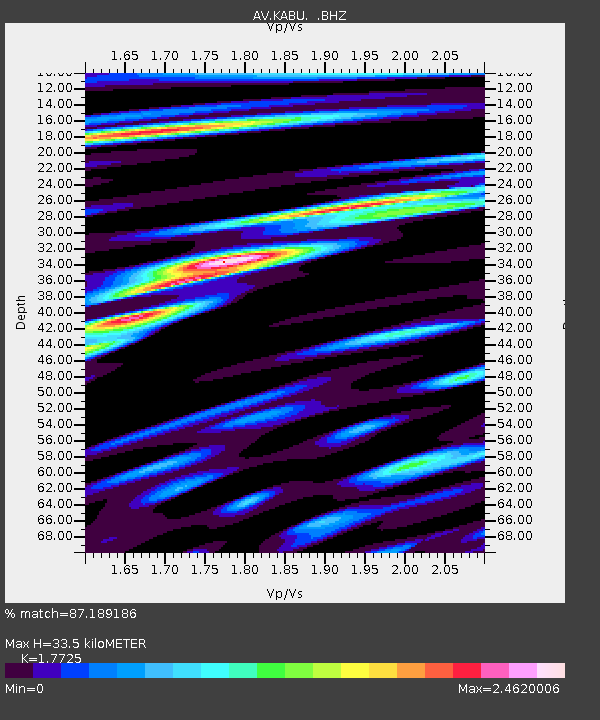
KABU KABU - Katmai Volcanic Cluster, Alaska - Earthquake Result Viewer
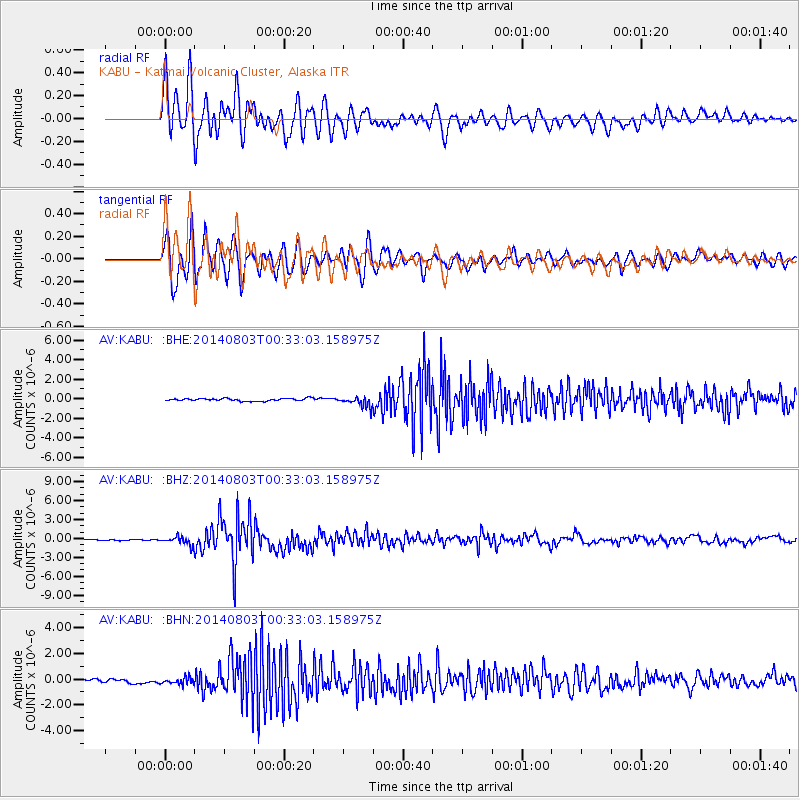
Earthquake location: E. Caroline Islands, Micronesia
Earthquake latitude/longitude: 0.8/146.1
Earthquake time(UTC): 2014/08/03 (215) 00:22:03 GMT
Earthquake Depth: 11 km
Earthquake Magnitude: 6.9 MWW, 6.8 MWB, 6.9 MWC, 7.2 MI
Earthquake Catalog/Contributor: NEIC PDE/NEIC COMCAT
Network: AV Alaska Volcano Observatory
Station: KABU KABU - Katmai Volcanic Cluster, Alaska
Lat/Lon: 58.27 N/155.28 W
Elevation: 1065 m
Distance: 73.3 deg
Az: 28.092 deg
Baz: 242.993 deg
Ray Param: 0.053116396
Estimated Moho Depth: 33.5 km
Estimated Crust Vp/Vs: 1.77
Assumed Crust Vp: 6.438 km/s
Estimated Crust Vs: 3.632 km/s
Estimated Crust Poisson's Ratio: 0.27
Radial Match: 87.189186 %
Radial Bump: 400
Transverse Match: 88.860054 %
Transverse Bump: 400
SOD ConfigId: 769524
Insert Time: 2014-08-17 00:42:43.416 +0000
GWidth: 2.5
Max Bumps: 400
Tol: 0.001

Signal To Noise

ChannelStoNSTALTA
AV:KABU: :BHZ:20140803T00:33:03.158975Z9.4296147.4954903E-77.948883E-8
AV:KABU: :BHN:20140803T00:33:03.158975Z2.3905252.6278246E-71.09926674E-7
AV:KABU: :BHE:20140803T00:33:03.158975Z3.93621045.3703644E-71.3643489E-7
Arrivals
Ps4.2 SECOND
PpPs14 SECOND
PsPs/PpSs18 SECOND