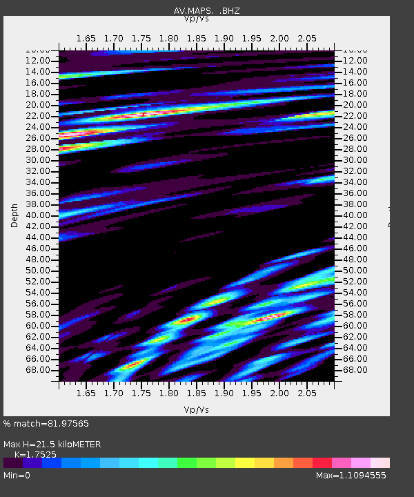
MAPS Pakushin Southeast, Makushin Volcano, Alaska - Earthquake Result Viewer
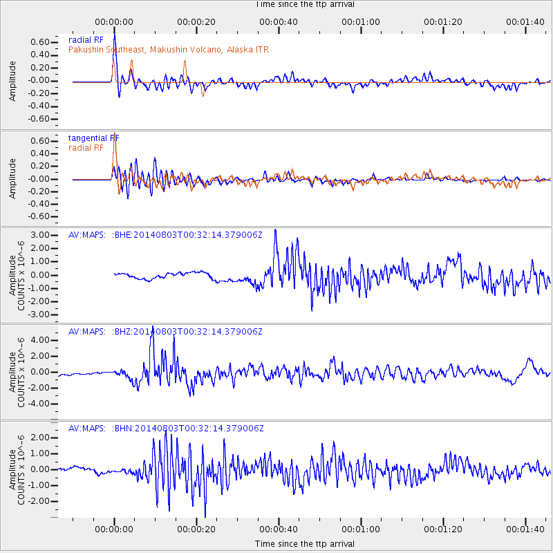
Earthquake location: E. Caroline Islands, Micronesia
Earthquake latitude/longitude: 0.8/146.1
Earthquake time(UTC): 2014/08/03 (215) 00:22:03 GMT
Earthquake Depth: 11 km
Earthquake Magnitude: 6.9 MWW, 6.8 MWB, 6.9 MWC, 7.2 MI
Earthquake Catalog/Contributor: NEIC PDE/NEIC COMCAT
Network: AV Alaska Volcano Observatory
Station: MAPS Pakushin Southeast, Makushin Volcano, Alaska
Lat/Lon: 53.81 N/166.94 W
Elevation: 333 m
Distance: 65.4 deg
Az: 28.458 deg
Baz: 233.455 deg
Ray Param: 0.05831927
Estimated Moho Depth: 21.5 km
Estimated Crust Vp/Vs: 1.75
Assumed Crust Vp: 3.943 km/s
Estimated Crust Vs: 2.25 km/s
Estimated Crust Poisson's Ratio: 0.26
Radial Match: 81.97565 %
Radial Bump: 400
Transverse Match: 75.816666 %
Transverse Bump: 400
SOD ConfigId: 769524
Insert Time: 2014-08-17 00:42:49.163 +0000
GWidth: 2.5
Max Bumps: 400
Tol: 0.001

Signal To Noise

ChannelStoNSTALTA
AV:MAPS: :BHZ:20140803T00:32:14.379006Z3.51461866.296723E-71.7915808E-7
AV:MAPS: :BHN:20140803T00:32:14.379006Z0.73684551.1654983E-71.5817403E-7
AV:MAPS: :BHE:20140803T00:32:14.379006Z2.39675475.2483057E-72.1897549E-7
Arrivals
Ps4.2 SECOND
PpPs15 SECOND
PsPs/PpSs19 SECOND