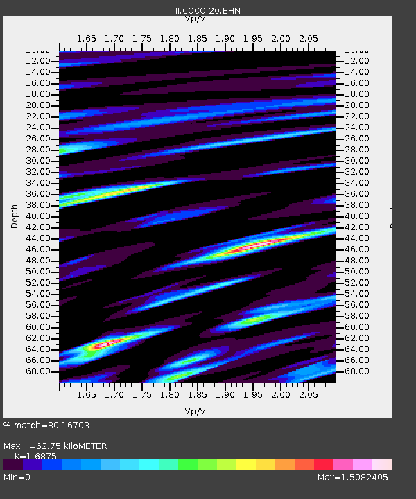
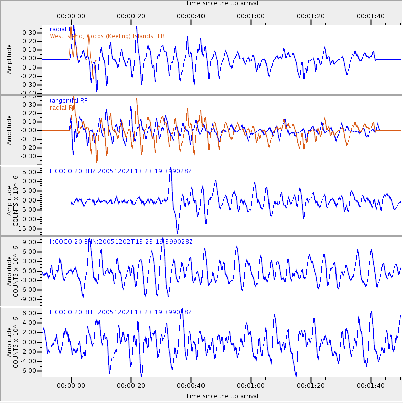
COCO West Island, Cocos (Keeling) Islands - Earthquake Result Viewer

Earthquake location: Near East Coast Of Honshu, Japan
Earthquake latitude/longitude: 38.1/142.1
Earthquake time(UTC): 2005/12/02 (336) 13:13:09 GMT
Earthquake Depth: 29 km
Earthquake Magnitude: 6.1 MB, 6.3 MS, 6.5 MW, 6.4 MW
Earthquake Catalog/Contributor: WHDF/NEIC
Network: II Global Seismograph Network (GSN - IRIS/IDA)
Station: COCO West Island, Cocos (Keeling) Islands
Lat/Lon: 12.19 S/96.83 E
Elevation: 1.0 m
Distance: 65.5 deg
Az: 229.754 deg
Baz: 38.023 deg
Ray Param: 0.058155376
Estimated Moho Depth: 62.75 km
Estimated Crust Vp/Vs: 1.69
Assumed Crust Vp: 4.24 km/s
Estimated Crust Vs: 2.513 km/s
Estimated Crust Poisson's Ratio: 0.23
Radial Match: 80.16703 %
Radial Bump: 400
Transverse Match: 78.07781 %
Transverse Bump: 400
SOD ConfigId: 2422
Insert Time: 2010-03-02 00:39:19.200 +0000
GWidth: 2.5
Max Bumps: 400
Tol: 0.001

Signal To Noise

ChannelStoNSTALTA
II:COCO:20:BHN:20051202T13:23:19.399028Z2.3986133.2811074E-61.3679187E-6
II:COCO:20:BHE:20051202T13:23:19.399028Z1.2451371.6287712E-61.3081061E-6
II:COCO:20:BHZ:20051202T13:23:19.399028Z7.4489836.5956615E-68.8544454E-7
Arrivals
Ps10 SECOND
PpPs39 SECOND
PsPs/PpSs49 SECOND