You are here: Home > Network List > II - Global Seismograph Network (GSN - IRIS/IDA) Stations List
> Station COCO West Island, Cocos (Keeling) Islands > Earthquake Result Viewer
COCO West Island, Cocos (Keeling) Islands - Earthquake Result Viewer
| Earthquake location: |
Banda Sea |
| Earthquake latitude/longitude: |
-5.5/128.1 |
| Earthquake time(UTC): |
2006/01/27 (027) 16:58:53 GMT |
| Earthquake Depth: |
397 km |
| Earthquake Magnitude: |
7.0 MB, 7.6 MW, 7.5 MW |
| Earthquake Catalog/Contributor: |
WHDF/NEIC |
|
| Network: |
II Global Seismograph Network (GSN - IRIS/IDA) |
| Station: |
COCO West Island, Cocos (Keeling) Islands |
| Lat/Lon: |
12.19 S/96.83 E |
| Elevation: |
1.0 m |
|
| Distance: |
31.6 deg |
| Az: |
255.674 deg |
| Baz: |
80.576 deg |
| Ray Param: |
0.077535145 |
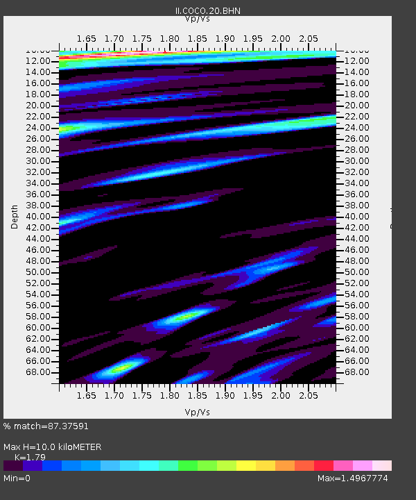
| Estimated Moho Depth: |
10.0 km |
| Estimated Crust Vp/Vs: |
1.79 |
| Assumed Crust Vp: |
4.24 km/s |
| Estimated Crust Vs: |
2.369 km/s |
| Estimated Crust Poisson's Ratio: |
0.27 |
|
| Radial Match: |
87.37591 % |
| Radial Bump: |
335 |
| Transverse Match: |
69.955124 % |
| Transverse Bump: |
384 |
| SOD ConfigId: |
4977 |
| Insert Time: |
2010-03-02 00:39:27.620 +0000 |
| GWidth: |
2.5 |
| Max Bumps: |
400 |
| Tol: |
0.001 |
|
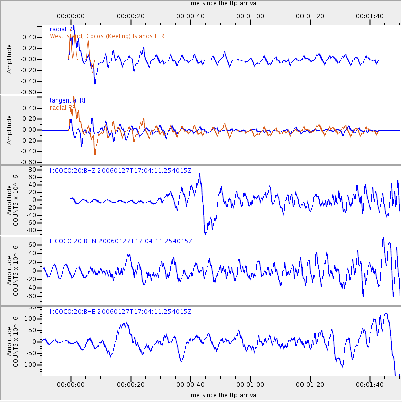
Signal To Noise
| Channel | StoN | STA | LTA |
| II:COCO:20:BHN:20060127T17:04:11.254015Z | 1.5312752 | 9.128228E-6 | 5.961194E-6 |
| II:COCO:20:BHE:20060127T17:04:11.254015Z | 2.266122 | 1.706636E-5 | 7.531086E-6 |
| II:COCO:20:BHZ:20060127T17:04:11.254015Z | 4.232435 | 1.2430197E-5 | 2.9368903E-6 |
| Arrivals |
| Ps | 1.9 SECOND |
| PpPs | 6.4 SECOND |
| PsPs/PpSs | 8.3 SECOND |


