You are here: Home > Network List > II - Global Seismograph Network (GSN - IRIS/IDA) Stations List
> Station COCO West Island, Cocos (Keeling) Islands > Earthquake Result Viewer
COCO West Island, Cocos (Keeling) Islands - Earthquake Result Viewer
| Earthquake location: |
Tonga Islands |
| Earthquake latitude/longitude: |
-16.9/-174.2 |
| Earthquake time(UTC): |
2000/01/08 (008) 16:47:20 GMT |
| Earthquake Depth: |
183 km |
| Earthquake Magnitude: |
6.5 MB, 6.6 MS, 7.2 MW, 7.0 ME |
| Earthquake Catalog/Contributor: |
WHDF/NEIC |
|
| Network: |
II Global Seismograph Network (GSN - IRIS/IDA) |
| Station: |
COCO West Island, Cocos (Keeling) Islands |
| Lat/Lon: |
12.19 S/96.83 E |
| Elevation: |
1.0 m |
|
| Distance: |
85.5 deg |
| Az: |
258.692 deg |
| Baz: |
106.258 deg |
| Ray Param: |
0.044291683 |
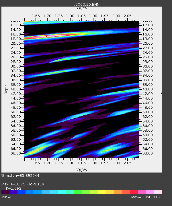
| Estimated Moho Depth: |
16.75 km |
| Estimated Crust Vp/Vs: |
1.70 |
| Assumed Crust Vp: |
4.24 km/s |
| Estimated Crust Vs: |
2.501 km/s |
| Estimated Crust Poisson's Ratio: |
0.23 |
|
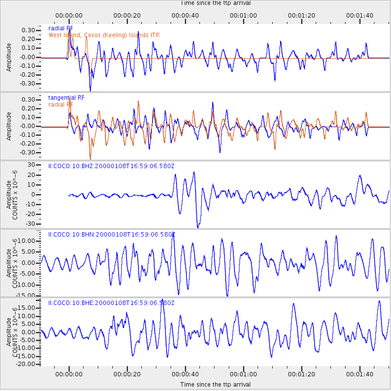
| Radial Match: |
85.892044 % |
| Radial Bump: |
400 |
| Transverse Match: |
78.53105 % |
| Transverse Bump: |
400 |
| SOD ConfigId: |
3744 |
| Insert Time: |
2010-03-02 00:39:40.958 +0000 |
| GWidth: |
2.5 |
| Max Bumps: |
400 |
| Tol: |
0.001 |
|
Signal To Noise
| Channel | StoN | STA | LTA |
| II:COCO:10:BHN:20000108T16:59:06.580Z | 0.8904119 | 2.1095598E-6 | 2.3691953E-6 |
| II:COCO:10:BHE:20000108T16:59:06.580Z | 0.73383343 | 2.3048601E-6 | 3.1408492E-6 |
| II:COCO:10:BHZ:20000108T16:59:06.580Z | 1.0311081 | 1.297125E-6 | 1.2579912E-6 |
| Arrivals |
| Ps | 2.8 SECOND |
| PpPs | 11 SECOND |
| PsPs/PpSs | 13 SECOND |


