You are here: Home > Network List > II - Global Seismograph Network (GSN - IRIS/IDA) Stations List
> Station COCO West Island, Cocos (Keeling) Islands > Earthquake Result Viewer
COCO West Island, Cocos (Keeling) Islands - Earthquake Result Viewer
| Earthquake location: |
Mindanao, Philippines |
| Earthquake latitude/longitude: |
6.9/126.6 |
| Earthquake time(UTC): |
2001/01/01 (001) 06:57:04 GMT |
| Earthquake Depth: |
33 km |
| Earthquake Magnitude: |
6.4 MB, 7.2 MS, 7.5 MW, 7.3 ME |
| Earthquake Catalog/Contributor: |
WHDF/NEIC |
|
| Network: |
II Global Seismograph Network (GSN - IRIS/IDA) |
| Station: |
COCO West Island, Cocos (Keeling) Islands |
| Lat/Lon: |
12.19 S/96.83 E |
| Elevation: |
1.0 m |
|
| Distance: |
35.1 deg |
| Az: |
237.453 deg |
| Baz: |
58.868 deg |
| Ray Param: |
0.077323996 |
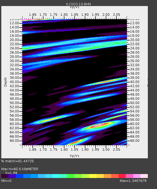
| Estimated Moho Depth: |
60.5 km |
| Estimated Crust Vp/Vs: |
1.96 |
| Assumed Crust Vp: |
4.24 km/s |
| Estimated Crust Vs: |
2.163 km/s |
| Estimated Crust Poisson's Ratio: |
0.32 |
|
| Radial Match: |
81.44725 % |
| Radial Bump: |
400 |
| Transverse Match: |
61.102398 % |
| Transverse Bump: |
400 |
| SOD ConfigId: |
3744 |
| Insert Time: |
2010-03-02 00:39:43.013 +0000 |
| GWidth: |
2.5 |
| Max Bumps: |
400 |
| Tol: |
0.001 |
|
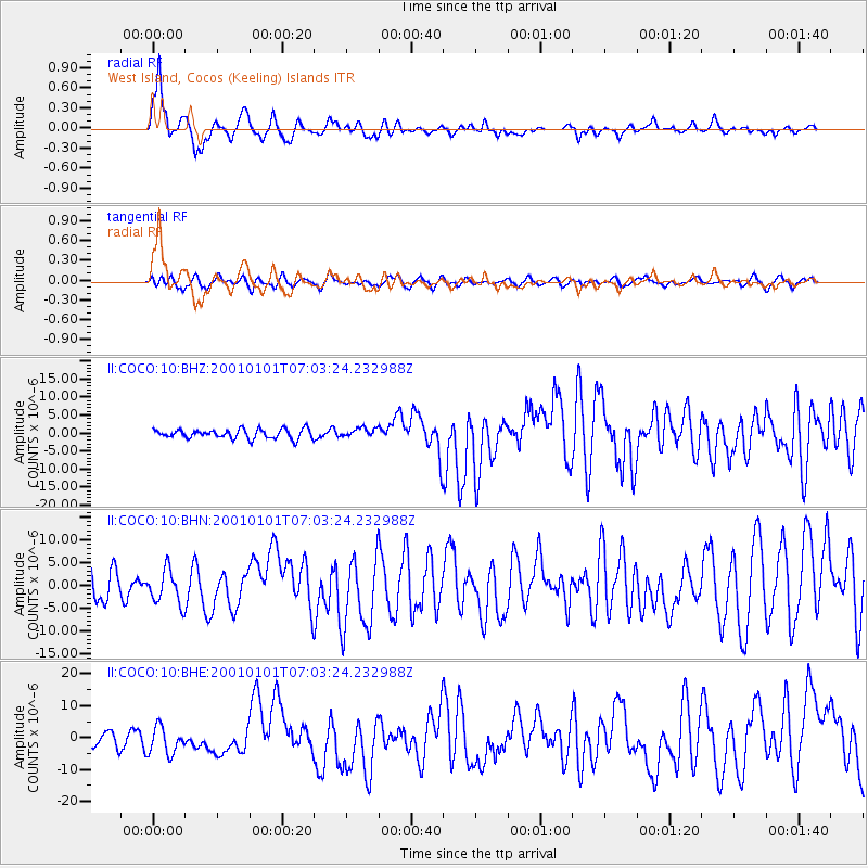
Signal To Noise
| Channel | StoN | STA | LTA |
| II:COCO:10:BHN:20010101T07:03:24.232988Z | 1.4476262 | 3.7266932E-6 | 2.5743477E-6 |
| II:COCO:10:BHE:20010101T07:03:24.232988Z | 1.2145662 | 4.2505862E-6 | 3.4996742E-6 |
| II:COCO:10:BHZ:20010101T07:03:24.232988Z | 0.97637683 | 1.246157E-6 | 1.2763074E-6 |
| Arrivals |
| Ps | 14 SECOND |
| PpPs | 41 SECOND |
| PsPs/PpSs | 55 SECOND |


