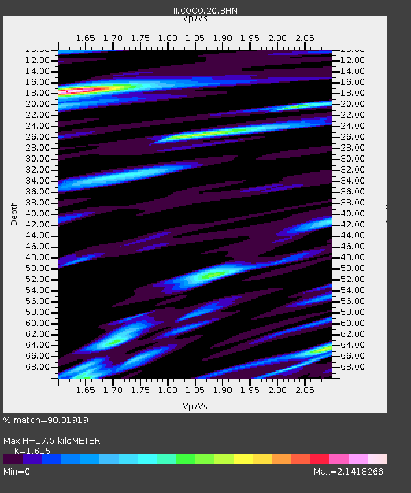
COCO West Island, Cocos (Keeling) Islands - Earthquake Result Viewer
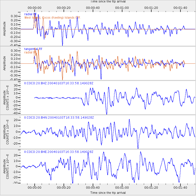
Earthquake location: Southeast Of Loyalty Islands
Earthquake latitude/longitude: -22.3/169.7
Earthquake time(UTC): 2004/01/03 (003) 16:23:21 GMT
Earthquake Depth: 22 km
Earthquake Magnitude: 6.4 MB, 7.1 MS, 7.1 MW, 6.8 MW
Earthquake Catalog/Contributor: WHDF/NEIC
Network: II Global Seismograph Network (GSN - IRIS/IDA)
Station: COCO West Island, Cocos (Keeling) Islands
Lat/Lon: 12.19 S/96.83 E
Elevation: 1.0 m
Distance: 69.7 deg
Az: 264.753 deg
Baz: 109.348 deg
Ray Param: 0.05541457
Estimated Moho Depth: 17.5 km
Estimated Crust Vp/Vs: 1.62
Assumed Crust Vp: 4.24 km/s
Estimated Crust Vs: 2.625 km/s
Estimated Crust Poisson's Ratio: 0.19
Radial Match: 90.81919 %
Radial Bump: 400
Transverse Match: 88.22402 %
Transverse Bump: 400
SOD ConfigId: 7314
Insert Time: 2010-03-02 00:39:45.951 +0000
GWidth: 2.5
Max Bumps: 400
Tol: 0.001

Signal To Noise

ChannelStoNSTALTA
II:COCO:20:BHN:20040103T16:33:58.149028Z2.25417833.2850542E-61.4573177E-6
II:COCO:20:BHE:20040103T16:33:58.149028Z2.52418523.6132556E-61.4314542E-6
II:COCO:20:BHZ:20040103T16:33:58.149028Z11.8556648.390684E-67.077364E-7
Arrivals
Ps2.6 SECOND
PpPs11 SECOND
PsPs/PpSs13 SECOND