You are here: Home > Network List > KZ - Kazakhstan Network Stations List
> Station KKAR Karatau array,KK31, Kazakhstan > Earthquake Result Viewer
KKAR Karatau array,KK31, Kazakhstan - Earthquake Result Viewer
| Earthquake location: |
E. Caroline Islands, Micronesia |
| Earthquake latitude/longitude: |
0.8/146.1 |
| Earthquake time(UTC): |
2014/08/03 (215) 00:22:03 GMT |
| Earthquake Depth: |
11 km |
| Earthquake Magnitude: |
6.9 MWW, 6.8 MWB, 6.9 MWC, 7.2 MI |
| Earthquake Catalog/Contributor: |
NEIC PDE/NEIC COMCAT |
|
| Network: |
KZ Kazakhstan Network |
| Station: |
KKAR Karatau array,KK31, Kazakhstan |
| Lat/Lon: |
43.11 N/70.51 E |
| Elevation: |
525 m |
|
| Distance: |
79.0 deg |
| Az: |
313.706 deg |
| Baz: |
99.274 deg |
| Ray Param: |
0.0492913 |
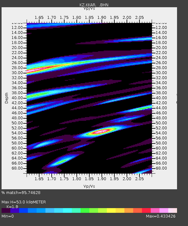
| Estimated Moho Depth: |
53.0 km |
| Estimated Crust Vp/Vs: |
1.90 |
| Assumed Crust Vp: |
6.316 km/s |
| Estimated Crust Vs: |
3.324 km/s |
| Estimated Crust Poisson's Ratio: |
0.31 |
|
| Radial Match: |
95.74628 % |
| Radial Bump: |
397 |
| Transverse Match: |
90.73862 % |
| Transverse Bump: |
400 |
| SOD ConfigId: |
769524 |
| Insert Time: |
2014-08-17 00:54:39.006 +0000 |
| GWidth: |
2.5 |
| Max Bumps: |
400 |
| Tol: |
0.001 |
|

Signal To Noise
| Channel | StoN | STA | LTA |
| KZ:KKAR: :BHZ:20140803T00:33:35.425027Z | 44.000065 | 2.851187E-6 | 6.479961E-8 |
| KZ:KKAR: :BHN:20140803T00:33:35.425027Z | 7.876407 | 3.387771E-7 | 4.301163E-8 |
| KZ:KKAR: :BHE:20140803T00:33:35.425027Z | 31.953526 | 1.0342784E-6 | 3.2368206E-8 |
| Arrivals |
| Ps | 7.8 SECOND |
| PpPs | 24 SECOND |
| PsPs/PpSs | 31 SECOND |


