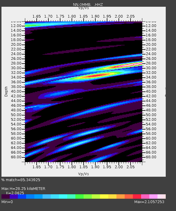
OMMB Old Mammoth Mine, surface, wgs-84 - Earthquake Result Viewer

Earthquake location: E. Caroline Islands, Micronesia
Earthquake latitude/longitude: 0.8/146.1
Earthquake time(UTC): 2014/08/03 (215) 00:22:03 GMT
Earthquake Depth: 11 km
Earthquake Magnitude: 6.9 MWW, 6.8 MWB, 6.9 MWC, 7.2 MI
Earthquake Catalog/Contributor: NEIC PDE/NEIC COMCAT
Network: NN Western Great Basin/Eastern Sierra Nevada
Station: OMMB Old Mammoth Mine, surface, wgs-84
Lat/Lon: 37.61 N/119.00 W
Elevation: 2768 m
Distance: 93.3 deg
Az: 52.432 deg
Baz: 273.621 deg
Ray Param: 0.04127925
Estimated Moho Depth: 28.25 km
Estimated Crust Vp/Vs: 2.06
Assumed Crust Vp: 6.291 km/s
Estimated Crust Vs: 3.05 km/s
Estimated Crust Poisson's Ratio: 0.35
Radial Match: 85.343925 %
Radial Bump: 400
Transverse Match: 68.04222 %
Transverse Bump: 400
SOD ConfigId: 769524
Insert Time: 2014-08-17 00:55:31.857 +0000
GWidth: 2.5
Max Bumps: 400
Tol: 0.001

Signal To Noise

ChannelStoNSTALTA
NN:OMMB: :HHZ:20140803T00:34:46.540017Z3.80907062.8138035E-77.3871135E-8
NN:OMMB: :HHN:20140803T00:34:46.540017Z1.40750949.4501615E-86.7141016E-8
NN:OMMB: :HHE:20140803T00:34:46.540017Z2.67990881.3557764E-75.059039E-8
Arrivals
Ps4.9 SECOND
PpPs14 SECOND
PsPs/PpSs18 SECOND