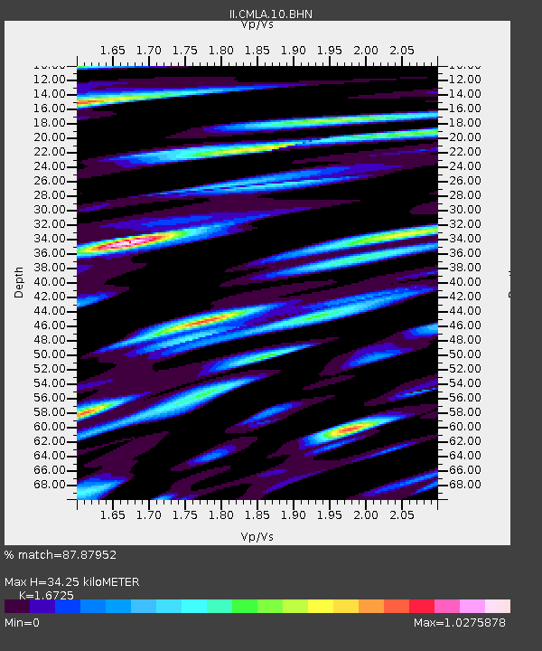
CMLA Cha de Macela, Sao Miguel Island, Azores - Earthquake Result Viewer

Earthquake location: Andreanof Islands, Aleutian Is.
Earthquake latitude/longitude: 51.6/-177.6
Earthquake time(UTC): 1996/06/10 (162) 04:03:35 GMT
Earthquake Depth: 33 km
Earthquake Magnitude: 6.6 MB, 7.6 MS, 7.9 UNKNOWN, 7.4 MS
Earthquake Catalog/Contributor: WHDF/NEIC
Network: II Global Seismograph Network (GSN - IRIS/IDA)
Station: CMLA Cha de Macela, Sao Miguel Island, Azores
Lat/Lon: 37.76 N/25.52 W
Elevation: 429 m
Distance: 87.8 deg
Az: 21.78 deg
Baz: 343.008 deg
Ray Param: 0.04305323
Estimated Moho Depth: 34.25 km
Estimated Crust Vp/Vs: 1.67
Assumed Crust Vp: 4.802 km/s
Estimated Crust Vs: 2.871 km/s
Estimated Crust Poisson's Ratio: 0.22
Radial Match: 87.87952 %
Radial Bump: 400
Transverse Match: 82.25902 %
Transverse Bump: 400
SOD ConfigId: 6273
Insert Time: 2010-03-02 00:39:59.608 +0000
GWidth: 2.5
Max Bumps: 400
Tol: 0.001

Signal To Noise

ChannelStoNSTALTA
II:CMLA:10:BHN:19960610T04:15:49.722021Z0.86276591.0875206E-61.2605047E-6
II:CMLA:10:BHE:19960610T04:15:49.722021Z0.876470151.165402E-61.3296539E-6
II:CMLA:10:BHZ:19960610T04:15:49.725012Z1.43188021.6699263E-61.1662471E-6
Arrivals
Ps4.9 SECOND
PpPs19 SECOND
PsPs/PpSs24 SECOND