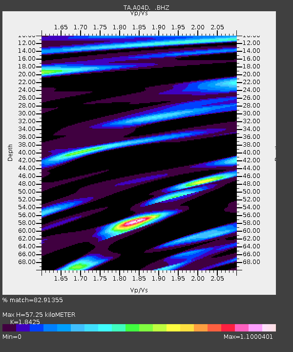
A04D Lummi Island, WA, USA - Earthquake Result Viewer
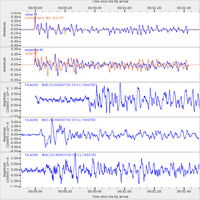
Earthquake location: E. Caroline Islands, Micronesia
Earthquake latitude/longitude: 0.8/146.1
Earthquake time(UTC): 2014/08/03 (215) 00:22:03 GMT
Earthquake Depth: 11 km
Earthquake Magnitude: 6.9 MWW, 6.8 MWB, 6.9 MWC, 7.2 MI
Earthquake Catalog/Contributor: NEIC PDE/NEIC COMCAT
Network: TA USArray Transportable Network (new EarthScope stations)
Station: A04D Lummi Island, WA, USA
Lat/Lon: 48.72 N/122.71 W
Elevation: 13 m
Distance: 90.1 deg
Az: 41.461 deg
Baz: 271.416 deg
Ray Param: 0.041695036
Estimated Moho Depth: 57.25 km
Estimated Crust Vp/Vs: 1.84
Assumed Crust Vp: 6.566 km/s
Estimated Crust Vs: 3.564 km/s
Estimated Crust Poisson's Ratio: 0.29
Radial Match: 82.91355 %
Radial Bump: 400
Transverse Match: 81.21784 %
Transverse Bump: 400
SOD ConfigId: 769524
Insert Time: 2014-08-17 00:58:29.354 +0000
GWidth: 2.5
Max Bumps: 400
Tol: 0.001

Signal To Noise

ChannelStoNSTALTA
TA:A04D: :BHZ:20140803T00:34:31.749978Z4.3315624.856571E-71.1212054E-7
TA:A04D: :BHN:20140803T00:34:31.749978Z0.91324691.1402098E-71.2485229E-7
TA:A04D: :BHE:20140803T00:34:31.749978Z0.91970631.3107626E-71.425197E-7
Arrivals
Ps7.5 SECOND
PpPs24 SECOND
PsPs/PpSs32 SECOND