You are here: Home > Network List > TA - USArray Transportable Network (new EarthScope stations) Stations List
> Station 109C Camp Elliot, Mirimar, CA, USA > Earthquake Result Viewer
109C Camp Elliot, Mirimar, CA, USA - Earthquake Result Viewer
| Earthquake location: |
E. Caroline Islands, Micronesia |
| Earthquake latitude/longitude: |
0.8/146.1 |
| Earthquake time(UTC): |
2014/08/03 (215) 00:22:03 GMT |
| Earthquake Depth: |
11 km |
| Earthquake Magnitude: |
6.9 MWW, 6.8 MWB, 6.9 MWC, 7.2 MI |
| Earthquake Catalog/Contributor: |
NEIC PDE/NEIC COMCAT |
|
| Network: |
TA USArray Transportable Network (new EarthScope stations) |
| Station: |
109C Camp Elliot, Mirimar, CA, USA |
| Lat/Lon: |
32.89 N/117.11 W |
| Elevation: |
150 m |
|
| Distance: |
95.2 deg |
| Az: |
57.038 deg |
| Baz: |
274.367 deg |
| Ray Param: |
0.040839832 |
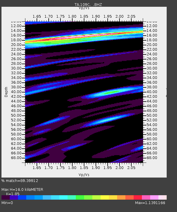
| Estimated Moho Depth: |
16.0 km |
| Estimated Crust Vp/Vs: |
1.85 |
| Assumed Crust Vp: |
6.264 km/s |
| Estimated Crust Vs: |
3.386 km/s |
| Estimated Crust Poisson's Ratio: |
0.29 |
|
| Radial Match: |
89.39912 % |
| Radial Bump: |
400 |
| Transverse Match: |
76.451866 % |
| Transverse Bump: |
400 |
| SOD ConfigId: |
769524 |
| Insert Time: |
2014-08-17 00:58:29.551 +0000 |
| GWidth: |
2.5 |
| Max Bumps: |
400 |
| Tol: |
0.001 |
|

Signal To Noise
| Channel | StoN | STA | LTA |
| TA:109C: :BHZ:20140803T00:34:55.093972Z | 4.2736154 | 2.7982125E-7 | 6.547648E-8 |
| TA:109C: :BHN:20140803T00:34:55.093972Z | 1.1114799 | 5.988436E-8 | 5.3878043E-8 |
| TA:109C: :BHE:20140803T00:34:55.093972Z | 2.153634 | 1.1758396E-7 | 5.4597926E-8 |
| Arrivals |
| Ps | 2.2 SECOND |
| PpPs | 7.1 SECOND |
| PsPs/PpSs | 9.4 SECOND |


